- Two people, including a child, dead after Oklahoma tornadoes; governor declares state of emergency
- Build your hurricane season preparedness kits this tax-free weekend
- Residents begin going through the rubble after tornadoes hammer parts of Nebraska and Iowa
- Midwest tornadoes flatten homes in Nebraska suburbs and leave trails of damage in Iowa
- WATCH: Massive tornado caught on camera in Iowa
Tropical Depression Bertha rain causes creek flooding in Charlotte
Rainfall amounts of 1-3 inches were expected east of I-77 with up to 25 mph winds as the center of Tropical Depression Bertha moved inland.
CHARLOTTE, N.C. — The worst of the rain is moving out, but flash flood warnings remain in effect for a few more hours, WCNC Chief Meteorologist Brad Panovich said.
The National Weather Service issued a Flash Flood Warning for Mecklenburg County after rainfall from Tropical Depression Bertha caused creeks across the Charlotte area to rise.
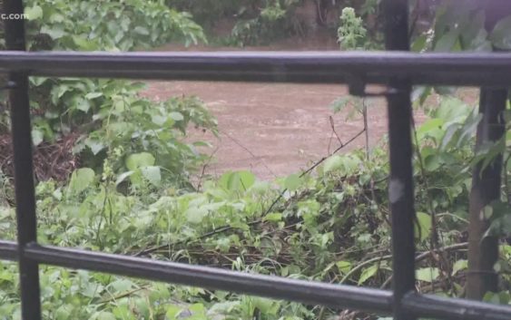
McMullen Creek has risen to the point of flooding Addison Drive in Charlotte’s Sherwood Forecast neighborhood. A United States Geological Survey camera at the location showed water flowing over the roadway by 6 p.m.
A creek gauge near the bridge showed McMullen Creek rose from just over one foot Wednesday morning to near 8 feet by Wednesday evening.
A rain gauge near South Sharon Amity Road and Randolph Road measured 1.40 inches of rain around 6 p.m.
Creeks are having to manage localized rainfall in addition to rainfall upstream.
Another gauge along Little Sugar Creek outside Atrium Health’s Carolina Medical Center in Charlotte showed that creek rising.
By 6 p.m., the creek was over 8 feet and approaching the banks of the creek. Hours earlier it had already flooded out the nearby greenway leading to Freedom Park.
Another USGS camera near Kings Drive showed water levels had risen into the nearby green space.
In Matthews, Sam Newell Road between Independence Point Parkway and Highway 51 was closed due to high water.
For the past week, rain had been falling in Charlotte and across the Carolinas. Already high waterways, combined with saturated soils, increased the likelihood of flooding Wednesday as the remnants of Tropical Storm Bertha moved through the region.
The unlikely storm formed off the coast of South Carolina only hours earlier before quickly moving onshore.
At 5 p.m. Bertha was located about 55 miles east northeast of Columbia, South Carolina moving further inland at north northwest near 15 mph.
Bertha made landfall around 9:30 a.m. near Mount Pleasant, SC.
A turn toward the north at a faster forward speed is expected tonight, followed by a turn toward the north-northeast on Thursday, according to the National Hurricane Center. On the forecast track, Bertha will move across northern South Carolina this evening and into central North Carolina and southwestern Virginia later tonight.
Maximum sustained winds have decreased to 30 mph with higher gusts. Bertha is expected to continue to weaken to a remnant low tonight.
Bertha is the second named storm of the year. The hurricane season officially starts on Monday.
Bertha is expected to produce total rain accumulation of 2 to 4 inches with isolated totals of 8 inches across eastern and central South Carolina into west central to far southeastern North Carolina and southwest Virginia. This rainfall may produce life-threatening flash flooding.
A Flash Flood Watch is in effect through late into the evening for Mecklenburg and surrounding counties. The tropical low is moving through with a lot of rain.
Rain moved into the area midday and with heavier bands in the late afternoon.
The race at Charlotte Motor Speedway is expected to start at 8 p.m.
“Almost all the guidance shows pretty heavy rain parked right on the track so I don’t see this starting on time,” said Chief Meteorologist Brad Panovich. “Is there a chance we could go later into the night? I think that’s up to NASCAR.”
Panovich says there is a small window around 9 p.m. when the rain will stop and they might be able to get the race in.
Rainfall amounts of 1-3 inches is expected east of I-77 with up to 25 mph winds as the remnants of Bertha move through.
Rain chances decrease after 8 p.m.
This rainfall will combine with already nearly saturated soils to cause rapid stream rises and threat of flash flooding.
The rain is more scattered later into the evening. The rain will clear out overnight.
A Flash Flood Watch means that conditions may develop that lead to flash flooding. Download the WCNC app to be alerted of weather watches and warnings in your area.