- Here's how to get your flooding debris picked up by the City of Houston
- Mosquito activity on the rise due to rainfall, flooding across Texas
- Volunteers help Conroe community clean up in wake of flooding in Montgomery County
- Why leaders are urging NC residents to start hurricane prep now
- Storms could produce hail, damaging winds south of Charlotte
Developing system could be earliest 3rd tropical storm on record
An already active Atlantic hurricane season — which hasn’t officially begun yet — could take a turn for the record books with a new disturbance that looks poised to strengthen. The season officially begins on June 1.
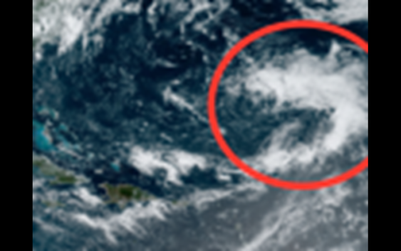
Forecasters are now monitoring an area of low pressure designated as Invest 92L, which was developing Friday morning about 700 miles southeast of Bermuda, and they say it could strengthen further in the coming days. Satellite images on Friday morning showed an area of showers and thunderstorms beginning to become better organized with a notable swirl of low pressure.
The busy start to the year kicked off with the formation of Tropical Storm Arthur on May 16, and the system narrowly missed the Outer Banks of North Carolina. That was followed by the rapid development of Tropical Storm Bertha less than two weeks later on May 27. Bertha made an unusually early landfall in the United States near Charleston, South Carolina, on Wednesday.
AccuWeather meteorologists have been warning that the 2020 Atlantic hurricane season could be a very active one, and so far it’s playing out that way. There have been only five years where two storms have been named in the Atlantic during May or earlier, including 2016, 2012, 1951, 1908 and 1887.
When a pocket of cold air in the atmosphere sits over warm water, the two elements can lead to the formation of a low-pressure system closer to the ocean surface. That process appeared to be underway Friday and may fully form a tropical system in the next 24-36 hours.
This area of disturbed weather has already been designated as an invest area, meaning that the National Hurricane Center (NHC) is interested in collecting extra information or investigating the area in question. Any information the NHC gathers provides forecasters more data with which to determine the possibility of development.
As of Friday morning, the system had struggled to develop due to wind shear, or changing wind speeds or directions at high altitude. However, if the disturbance can become better organized, it may become less susceptible to the effects of wind shear.
Typically, tropical systems develop and strengthen most efficiently when they are over water temperatures of 80 F or higher. Invest 92L was moving over an area where ocean water temperatures were ranging between 75 and 77 on Friday morning, but very warm water was located just to the south. However, if the disturbance is to strengthen enough to be given a name, it would need to develop quickly, as it will begin moving northward over cooler waters on Friday afternoon.
Regardless of development, the system should stay at least 300 miles east of Bermuda. Therefore, any potential storm that develops should bring little impact to Bermuda other than generating slightly elevated seas and rough surf.
Even though preseason tropical storm formation is not uncommon, the development of three named storms before June 1 has never happened in the Atlantic Basin.
Prior to the satellite era, there were likely a number of tropical systems that went undetected over the world’s oceans, including the Atlantic from the 1960s on back.
“In 1951, a tropical storm formed in January, then a hurricane followed in May and another tropical system, a depression also formed that same May,” according to AccuWeather Senior Meteorologist Alex Sosnowski.
But officially, if this area strengthens into a named tropical system, it would be the earliest third tropical storm on record in the Atlantic. And it would be given the name Cristobal, which is next on the predetermined 2020 Atlantic name list.
“The earliest number-three tropical storm on record is Colin, which formed on June 5, 2016,” AccuWeather Senior Meteorologist Joe Lundberg said.
Typically, the third named storm usually develops much later in the season, occurring on average in August. “Aug. 13 is the average date of the third named storm,” said AccuWeather Senior Meteorologist Kristina Pydynowski.
The same list of names is used every six years, unless a storm is unusually strong or deadly. The name Cristobal was most recently used in 2014. That year, Cristobal did not form until late August.
Another hotspot for tropical activity may emerge in the Atlantic, but forecasters say conditions could take longer to come together in this zone. An area of low pressure could form in the southwestern Gulf of Mexico or northwestern Caribbean Sea sometime next week. The developing low-pressure area could strengthen into a more organized tropical system as early as next weekend, but AccuWeather forecasters say that sort of development is more likely to happen during the second week of June. Historically, storms that develop in this region of the Atlantic basin are most likely to impact the U.S. directly at this time of the year.
Stay tuned to AccuWeather’s hurricane center for the latest updates on potential tropical development.
Keep checking back on AccuWeather.com and stay tuned to the AccuWeather Network on DirecTV, Frontier and Verizon Fios.