- Rock Hill storm damage costs are 'somewhere around $5 million.' That number doesn't include damage to personal property
- Rock Hill storm damage costs are 'somewhere around $5 million.' That number doesn't include damage to personal property
- ‘Somewhere around $5 million’ | Rock Hill officials see major storm damage costs
- The deadliest tornadoes to ever hit Austin
- Whiteville resident recalls events from Tuesday nights tornado
Gulf coast residents urged to keep close tabs on the gulf. Tropical Storm development possible this week
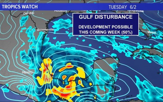
The National Hurricane Center is monitoring an area of low pressure that may develop into our next named system.
HOUSTON — The National Hurricane Center is urging all residents along the gulf coast to keep a close eye on the gulf due to possible development this week.
As of Sunday afternoon, the NHC has increased the probability of development to 50 percent over the next five days.
It is far too early for specifics but here’s what we know as of right now:
What
Tropical Storm Amanda from the eastern Pacific developed early Sunday and made landfall soon after in Guatemala and quickly weakened.
The remnant low of Amanda will continue to move northward over central America and southern Mexico before emerging in the Bay of Campeche by Tuesday.
Sequence of Events
Once this system splashes into the gulf, the NHC will likely declare it Invest 93L. That’s just a fancy term for an area that’s being closely monitored or investigated hints the name ‘invest.’
Once in the gulf, reconnaissance missions will likely begin to determine if the storm has closed off a circulation. If it has, it will become a tropical depression or tropical storm; depending on wind speed.
At this point, we’ll get a cone and an official track from the NHC.
Watches & Warnings
There are no watches or warnings at this time.
Tropical Storm Watches are issued 48 hours in advance of possible landfall.
Tropical Storm Warnings are issued 36 hours before an expected landfall.
When
If a storm develops, it would likely be Wednesday or Thursday of this week as it continues its trek into the central and northern Gulf of Mexico.
A possible landfall between Brownsville and the Florida panhandle would not be until the upcoming weekend or very early the following week.
Where
Simply too early to know. Please check back.
There is strong model agreement that this system will move into the central and northern gulf. All areas from the Florida panhandle to Brownsville, Texas will need to monitor this system closely. A large envelope of models exists with many of them favoring Texas and Louisiana.
The model above is the European ensembles. It’s ONE run of ONE model suite. Please do not focus on any one stretch of the coast.
How Strong
Simply too early to know. Please check back.
June cyclones are usually very weak and disorganized systems — still being sheared apart from the westerlies as the seasons continue to transition into Summer. However all systems are different.
The current thinking is anything that would develop would on the weaker side of things with a depression or tropical storm the most likely outcome. Of course models show a wide range of possibilities so it’s important to keep watching.
Possible Impacts:
Simply too early to know. Please check back.