- Severe weather leads to fallen trees, car crashes and flooding around the Triangle
- New video shows vehicles being swept away in historic, deadly flash floods in SA on June 12
- $40 million to go to underserved SC counties for Hurricane Helene recovery. Here's what you need to know.
- Family honors Air Force veteran Derwin Anderson Jr. after he died in June flash floods
- City of Wilmington addresses flooding on New Centre Drive
Tropical Storm Cristobal Likely to Threaten Texas/Louisiana, but As What?

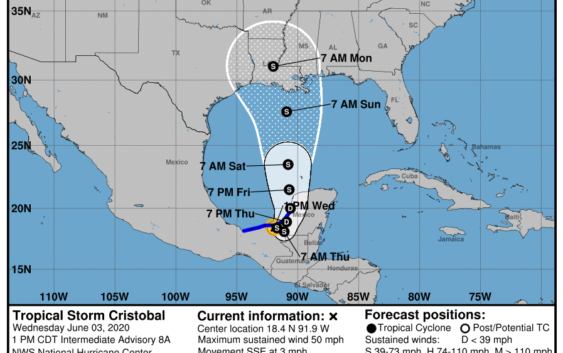
Tropical Storm Cristobal is drifting around just onshore in Mexico south of the Bay of Campeche as of writing this, and the longer it remains over land, the more disorganized it will be when it reemerges later this week. After that time, the forecast models seem in fairly good agreement about forecast track, but how much or if it strengthens is up in the air.
Cristobal is a rather unique storm in that it is not only very early in the season but it is a storm embedded in a larger area of disturbed weather called a gyre. In fact, Cristobal is actually the remnant of Tropical Storm Amanda, which came onshore last over the weekend and killed at least 17 people in El Salvador and Guatemala. It became ensnared in the gyre — essentially a large rotating area of weather — and moved off the Mexican coast into the Gulf. It continues to bring torrential rain to Mexico and parts of Central America.
The question right now is what will emerge from the Coast of Mexico? The longer the storm spends over land, the more it will weaken. A more disorganized storm over the central Gulf of Mexico on Friday would not give it much time to regenerate before another landfall. If it manages to get away from land sooner, we could see some intensification, however.
The good news is there is a lot of dry air that is expected to inhibit Cristobal’s development between now and next weekend. So far, only one of the intensity forecast models is predicting modest hurricane strength when the storm makes landfall, likely along the central Louisiana coastline. But, it is still very early and the storm absolutely bears watching.
While most of the models have focused in on a U.S. landfall somewhere between Houston and Mississippi, that is a very big bullseye, so that track could shift over time as the storm changes. We should have better picture of both forecast and intensity by Friday with an expected landfall late Sunday or early Monday.
If the forecasts hold, we are going to be on the dry side of the system and may not even see any rainfall. If we get a closer hit, it could mean some heavy rain and wind, nothing we aren’t used to. And because Cristobal is expected to pick up speed around the edge of a high pressure system, it is unlikely to remain in the area long enough to cause more than some minor street flooding.
But, stay tuned.