- Hurricane survival kit: How to keep your family safe when a hurricane hits
- Houston-area storm damage: Update on status of schools, power outages and resources for storm victims
- EF-1 tornadoes ripped through Cypress, Waller County areas with winds at more than 100 mph, NWS reports
- Houston-area storm damage updates: Clean up continues after NWS says two EF-1 tornadoes and powerful derecho ripped through SE Texas
- Low risk of damaging winds, hail from Saturday storms
Triangle now included in severe weather risk this afternoon
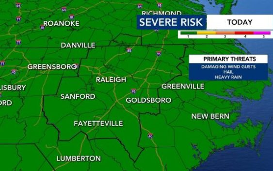
Severe weather will be possible across central North Carolina late Tuesday afternoon and evening.
WRAL meteorologist Elizabeth Gardner said the entire viewing area is under a level 1 risk for severe weather, with storms expected to move in no earlier than 4 or 5 p.m. Damaging winds and heavy rain are possible.
The first half of Tuesday will be mostly dry, with temperatures reaching 82 degrees by 10 a.m.
The first storms could move in late Tuesday afternoon, when temperatures climb into the upper 80s, topping out around 90 degrees in Raleigh.
There is a greater chance for thunderstorms on Wednesday, which is also under a level 1 threat for severe weather.

Thursday will be cloudy but calmer, with just a small chance for storms. Friday and the weekend should not see any storms or rain.
Temperatures will stay warm all week, with highs in the upper 80s expected Wednesday, Thursday and Friday. On Saturday and Sunday, highs will be in the low 90s.