- Texas flooding: Emergency crews rescue stranded residents
- “We lost everything”: East Texas residents confront their future after flooding
- Conroe police officer critically injured in Trinity County tornado dies
- Flood risk and severe weather threat for Central Texas over the weekend
- ‘Hasn’t been this bad since Harvey': Woodloch residents in Montgomery County brace for more flooding
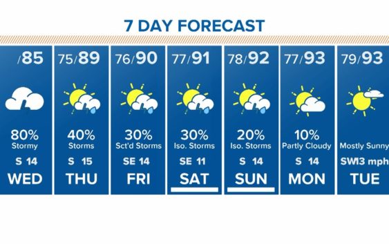
Houston Forecast: Flood watch canceled but heavy downpours persist
Continue to keep your guard up for high water spots as rain will be an issue throughout the day.
HOUSTON — More heavy downpours swept through the Houston area early this morning, but so far we have avoided the threat of widespread street flooding.
An earlier Flash Flood Watch and Flood Advisory have both expired, although we should stay weather aware today as more scattered downpours will continue through the afternoon.
As of 8 a.m. the heaviest rainfall was in our coastal communities.
TRAFFIC: View incidents/delays
TRACK THE WEATHER: Houston weather radar
GET ALERTS ON YOUR PHONE: Download the KHOU 11 app
The rain chances continue, but decrease, later this evening and going into Thursday and Friday.
This weekend we’ll still have a slight chance for scattered showers as the dust moves in. Temps will start to rise as more sunshine comes out, in the low-90s this weekend.
Since Friday of last week, we have had an influx of tropical moisture into the area, and it doesn’t take much to squeeze it out of the atmosphere in the form of showers. Think of a sponge that is soaked. One little squeeze, and water comes out.
The chance for scattered storms and downpours continues the entire workweek ahead of Saharan dust. The storm potential will diminish as we head into the end of the work week, and into the weekend, when the dust should be entering the Houston area.
The good news with the dust, which is over the Atlantic Ocean and moving into the Caribbean Sea soon, has helped keep the tropics calm, so no hurricanes and tropical storms anywhere in sight, likely for the rest of this month. Tropical Storm Dolly, is the exception, since it formed in the Northern Atlantic Ocean but will pose no threat to land.