- WATCH: Video Shows Confirmed Tornado touches down in Columbus County
- Residents begin clean up after storms, apparent tornado roll through NC Tuesday
- Flooding lingers in Liberty County neighborhoods near Trinity River with more rainfall expected
- North Carolina behind on hurricane preparedness, study shows
- North Carolina way behind on hurricane preparedness, study shows
2020 Atlantic hurricane season keeps beating records

The 2020 Atlantic hurricane season continues to progress at record pace.
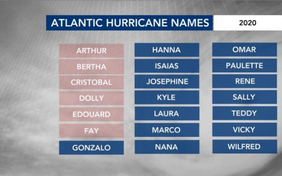
So far, six tropical storms formed – Arthur, Bertha, Cristobal, Dolly, Edouard and Fay.
Track the tropics anytime with WRAL’s interactive hurricane tracker
Tropical Storm Cristobal formed earlier than any other “C-storm” on record. Most recently, Tropical Storm Fay also became the earliest forming “F-storm” on record. The previous record was Franklin on July 22, 2005.
While the Atlantic has already had six named storms in 2020, none have become hurricanes. Dr. Philip Klotzbach – a meteorologist at Colorado State University (CSU) specializing in Atlantic basin seasonal hurricane forecasts – pointed out on Twitter that 2020 has “the most tropical storms on record (since 1851) to start an Atlantic hurricane season before the first hurricane occurred in 2011. Irene was the first hurricane that year – the 9th named storm of 2011.”
Out of the six tropical storms that formed so far, three of them impacted North Carolina in some way. Arthur and Fay both brought rain and wind to the Outer Banks with some rain across central North Carolina, while Bertha brought rain, wind and severe weather across the Carolinas.
Even though we have seen three Atlantic named storms make continental U.S. landfalls (Bertha, Cristobal and Fay), in 1886, three hurricanes made continental U.S. landfall by June 30. That is a rather impressive stat we all hope remains unsurpassed over the coming years.
What to expect going forward
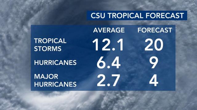
Meteorologists at CSU provide an excellent extended range forecast of Atlantic seasonal activity and this forecast is held to a high standard by many in the meteorological community. CSU’s tropical forecast was most recently updated on July 7, 2020, and still calls for an above-normal Atlantic hurricane season.
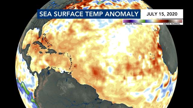
When commenting on his team’s rather active forecast, Dr. Klotzbach said, “One reason to continue to forecast an active Atlantic hurricane season is due to warmer than normal ocean temperatures in the tropical and most subtropical Atlantic.”
Warmer water provides more fuel for storms and can provide an unstable atmosphere promoting the strength of low-pressure systems and enhancing their overall longevity.
Think of the tropical Atlantic as a well-tuned car engine that does not have to deal with friction. In a sense, a car engine could just keep running and running until something messes it up. That too is similar to a hurricane moving across the Atlantic. Once a tropical low-pressure system forms with a proper input and output of energy, it can continue until it reaches land or an area with higher wind shear.
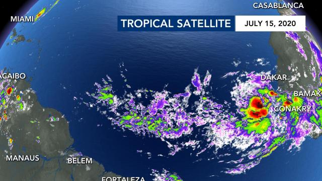
Dr. Klotzbach adds that “another reason for the active hurricane season forecast is due to a very active West African Monsoon. More robust easterly waves and weaker upper-level winds are conducive for development of tropical waves coming off the African landmass into enhanced tropical Atlantic activity.”
Tropical satellite from early on July 15 shows that rather active monsoon where rain is prevalent across western Africa. Those showers progress from east to west and eventually could develop into tropical systems. We usually see that in August, September and early October.
The 2020 Atlantic hurricane season has been rather active so far and it will continue to be active. On average, the first hurricane in the Atlantic forms around Aug. 10, and the first major hurricane forms around Sept. 4. Trust WRAL’s team of meteorologists to guide you through the rest of the season.


