- Seven months after Hurricane Helene, Chimney Rock rebuilds with resilience
- Wildfire in New Jersey Pine Barrens expected to grow before it’s contained, officials say
- Storm damage forces recovery efforts in Lancaster, Chester counties
- Evacuation orders lifted as fast-moving New Jersey wildfire burns
- Heartbreak for NC resident as wildfire reduces lifetime home to ashes
Rainfall, Possible Tropical Depression To Hit Dry South Texas

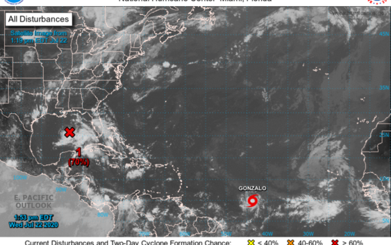
A tropical disturbance is expected to bring much needed rain relief to South Texas, including San Antonio this weekend.
The National Weather Service reported a disorganized tropical wave was located about 550 miles southeast of the Texas coast. It was moving west at about 10 miles an hour as of noon on Wednesday.
National Weather Service Meteorologist Orlando Bermudez said right now forecast models suggest rainfall of anywhere from 1 to 3 inches for the San Antonio area over the weekend and into Monday.
But Bermudez cautioned there are still a lot of unknowns about the system, such as exactly when it will arrive on the coast and whether it will grow into a tropical depression. Forecasters said “it is likely” to become a tropical depression.
That is the first stage of development. A tropical depression sometimes grows into a tropical storm and then into one or more of the five categories of hurricanes. But this particular storm is not expected to grow beyond tropical depression.
“Right now it still looks like it is not well organized,” Bermudez said. “The whole thing is we need to monitor it the next 24 to 48 hours.”
The San Antonio forecast as of Wednesday afternoon called for rain chances to begin picking up Friday night with a 40% chance of showers. There is a 70% chance Saturday and Saturday night, a 60% chance of showers on Sunday, and a 40% chance on Monday.
Accuweather Meteorologist John Feerick said while coastal arrival times and rainfall amounts still vary, one thing all models and forecasters agree on is rain is on its way to South Texas.
“Heading into Friday that’s when we will start to see more impacts across Texas, certainly the potential for some heavy rainfall and the potential for some flash flooding,” he said.
June and July have been virtually bone dry, and July also saw a heat wave that broke high temperature records at times.
The Edwards Aquifer Authority reports July started with a 3-inch annual rainfall deficit for the city.
Stage 1 water restrictions were imposed on San Antonians on July 10. Residents can only water landscaping with sprinklers or irrigation systems once a week based on street address.
The director of aquifer science at the authority, Paul Bertetti, told the authority board last Tuesday that without beneficial rainfall the city could be placed under Stage 2 water restrictions by the end of this month or early August.
Stage two restrictions are triggered when the water level in the underground porous limestone structure dips to 650 feet or below for 10 days.
Under stage two residents can still water landscape once a week with a sprinkler or irrigation system based on their address, but the hours to water on that day are cut in half.
The reading at the J-17 Well — the official measuring spot for the aquifer level — stood at 653.7 feet, but with a 10 day running average of 655.1 feet.
The aquifer is San Antonio’s largest source of water, and run-off from rain enters the aquifer in a recharge zone located in counties to the west and north of Bexar County and across northern Bexar County.
Rains near those spots prove the most beneficial for the aquifer level.
The National Hurricane Center is also watching Tropical Storm Gonzalo, which could reach hurricane strength on Thursday as it enters the eastern Caribbean.
Brian Kirkpatrick can be reached at Brian@TPR.org and on Twitter at @TPRBrian.
TPR was founded by and is supported by our community. If you value our commitment to the highest standards of responsible journalism and are able to do so, please consider making your gift of support today.