- Seven months after Hurricane Helene, Chimney Rock rebuilds with resilience
- Wildfire in New Jersey Pine Barrens expected to grow before it’s contained, officials say
- Storm damage forces recovery efforts in Lancaster, Chester counties
- Evacuation orders lifted as fast-moving New Jersey wildfire burns
- Heartbreak for NC resident as wildfire reduces lifetime home to ashes
Tropics update: Tropical Storm Hanna expected to become hurricane by tomorrow's landfall
Our forecast is looking better in Houston as the storm’s track continues to shift south.
HOUSTON — The KHOU weather team and National Hurricane Center are tracking two tropical systems, one of which could bring rain to the Houston area.
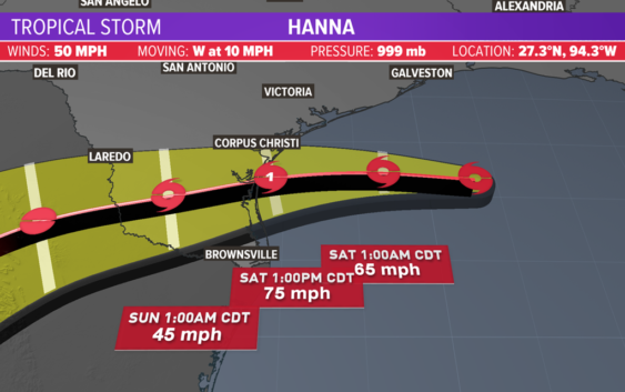
Tropical Storm Hanna is headed for the Texas coast and is expected to become a hurricane by landfall. It’s expected to make landfall south of Corpus Christi. Meanwhile, Tropical Storm Gonzalo is expected to dissipate over the next couple days as it moves westward from the Atlantic into the Caribbean Sea.
Get the updates on each below.
Tropical Storm Hanna
This is the primary concern for the Texas coast right now, especially the South Texas coast. There is a hurricane warning in effect from Baffin Bay to Mesquite Bay.
In Houston, we may only get 1 to 3 inches of rain widespread through the weekend. Closer to the coast, we may get 5 inches of rain. This is an improvement from when the forecast track was farther north, and Houston was in the cone of uncertainty.
The earlier Tropical Storm Watch for areas in Harris and Galveston counties has now been canceled, the National Weather Service in League City says.
Tropical Storm Watches and Warnings are still in effect, however, for parts of the Texas coast farther south heading toward Corpus Christi.
As of the 1 p.m. Friday update, Hanna’s forecast track has shifted southward, which is good news for Houston. It looks like, at this time, the Corpus Christi area will get the worst of it.
Upper-level wind patterns are sending the system towards Texas. It will bring an increased rain threat to Southeast Texas on Friday and Saturday.
Hanna has sustained winds of 50 mph and is moving west-northwestward at 9 mph.
It will not be much of a wind threat for Houston, and we are not expecting it to stall and dump several inches of water.
We’ll see some additional tropical moisture (rain) come our way across the Houston area, which means more robust and heavier downpours. The timing is from Friday to Sunday. We could see rough waves, gusty winds and torrential rain, bringing with it rain between 1 and 4 inches and localized flooding.
Even though we are out of the “cone of uncertainty,” our 7-day forecast shows plenty of rain for the Houston area, much of it due to this tropical system.
Tropical Storm Gonzalo in Atlantic
The second area that we are tracking is Tropical Storm Gonzalo. It is moving westward out of the Atlantic and into the Caribbean sea.
A first glance at the cone looks like it could be bad news for the Gulf of Mexico, but the National Hurricane Center says Gonzalo is “tiny” and could dissipate over the weekend, making it not a major threat to land at this time.
As of the 1 p.m. update on Friday, Gonzalo had winds of 45 mph and is moving west at 18 mph.