- Whiteville resident recalls events from Tuesday nights tornado
- Tornado damage reported in southern NC after Tuesday's severe storms
- If your home floods, here are steps you can take to address mold
- WATCH: Video Shows Confirmed Tornado touches down in Columbus County
- Residents begin clean up after storms, apparent tornado roll through NC Tuesday
South Texas Braces For Arrival Of Hanna, First Hurricane of 2020
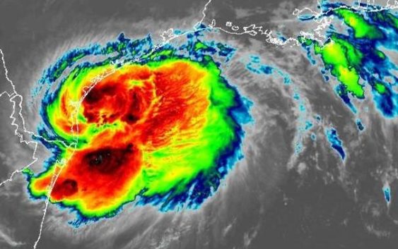
A South Texas region exhausted by a months-long struggle with COVID-19, drought and economic distress now turned to face one more massive challenge: Hanna, the first Atlantic hurricane of 2020.
The National Hurricane Center, or NHC, reported Saturday that Hanna was about 100 miles east-southeast of Corpus Christi and was moving west at 9 mph. Aircraft sent into the storm measured maximum sustained winds of 75 mph.
The sustained wind speed was the crucial threshold the tropical storm’s development had to cross to be reclassified as a hurricane. Hanna’s projected wind strength placed it in the lowest of five hurricane categories. However, the NHC warned that it expeceted Hanna to strengthen further before making landfall, or when the center of the storm reached the shore.
Corpus Christi and nearby communities in a region popularly known as the Coastal Bend felt the effects of the storm on Saturday morning.
As the sun rose over coastal communities bracing for impact, Hanna’s forecasted track moved slightly southward, taking Hanna from south of Corpus Christi through South Texas and towards the U.S. Mexico border.
Forecasters on Saturday morning issued a hurricane warning from Port Mansfield to Mesquite Bay.
“A Hurricane Warning means that hurricane conditions are expected somewhere within the warning area, in this case within the next 24 hours,” the NHC explained. “Preparations to protect life and property should be rushed to completion.”
A tropical storm warning stretched from the Barra el Mezquital in Mexico to Port Mansfield, and from Mesquite Bay to High Island.
“A Tropical Storm Warning means that tropical storm conditions are expected somewhere within the warning area, in this case within the next 24 hours,” the NHC statement added.
The Coastal Bend
Officials in the Corpus Christi area on Thursday and Friday urged residents not to underestimate the impact of Hanna, and at a Thursday press conference, Nueces County Judge Barbara Canales reminded residents that they were no strangers to tropical threats.
“Here’s how I like to think about it, I guess maybe I’ve mentioned it, I’m a sports fan, baseball fanatic family,” she said. “This is our first game of our season, and it’s not preseason anymore. So we have to get back into the groove but we have to remember this is not an exhibition game where it doesn’t count. This is our game day this weekend.”
Canales emphasized that it was important to prepare, not panic.
“It was almost shocking to hear the National Weather Service say ‘it’s headed right for Corpus Christi,'” she said on Friday, “but I ask you to think about being brave and being patient.”
Nueces County officials advised residents to prepare for power outages and to stay off the beaches and roads in the coming hours.
Corpus Christi City Manager Peter Zanoni said residents had to prepare for high winds, heavy rains, and possible flooding.
Latest Threats and Impacts as Tropical Storm #Hanna strengthens and approaches the Middle Texas Coast.
– Hurricane Warnings in effect
– Tropical Storm Warnings in effect
– Storm Surge Warnings in effect
– Flash Flood Watch in effect pic.twitter.com/ckYqYML1wz— NWS Corpus Christi (@NWSCorpus) July 24, 2020
Cornerstones of the Corpus Christi community responded to officials’ warnings to exercise caution. By Friday, Texas A&M University-Corpus Christi had closed its offices until Monday morning, and Del Mar College continued its restrictions to its campuses, with online teaching resuming on Monday. The Texas State Aquarium also closed early.
The Port of Corpus Christi explained in a statement on Friday that it moved to Condition 2, meaning that its security and police forces would assist “vessels seeking safe harbor and, in addition, monitor vessels that have been approved to moor at Port facilities.”
Webb County, Laredo and the Rio Grande Valley
In Laredo and Webb County, where forecasters expected Hanna to cross into Mexico, officials took a moment from fighting the COVID-19 outbreak to address the new challenge from Mother Nature.
“Not only do we have to worry about this, but we have to worry about a tropical depression that’s hit the Gulf, and we are in preparations for that,” said Ramiro Elizondo, Laredo’s interim fire chief and emergency manager, early on Friday.
Elizondo and other officials said they were concerned about flooding, and they would monitor the Rio Grande and floodplains throughout the county.
Here’s the latest loop (1:15pm-7:45pm CDT) of Tropical Storm #Hanna strengthening as it moves west through the Gulf of Mexico. #txwx #stxwx pic.twitter.com/D4eajLgiZG
— NWS Corpus Christi (@NWSCorpus) July 25, 2020
City Manager Robert Eads urged residents to hunker down at home to avoid straining the city’s resources.
“Just as important is this Tropical Storm Hanna because it affects our community,” he said, “which affects our response rates as well. So when you have a huge surge in water that is just concerning at a lot of different levels.”
In Brownsville, Cameron County officials announced plans to offer sandbags to residents in homes in low-lying areas.
Gov. Greg Abbott reported that the state had resources on standby in anticipation of severe weather affecting the Coastal Bend, the upper Rio Grande Valley and the Texas Hill Country.
San Antonio
The NHC explained on Saturday that “Hanna is expected to produce 6 to 12 inches of rain with isolated maximum totals of 18 inches through Sunday night in south Texas and into the Mexican states of Coahuila, Nuevo Leon, and northern Tamaulipas. This rain may result in life-threatening flash flooding, rapid rises on small streams, and isolated minor to moderate river flooding in south Texas. [Three] to 5 inches of rain is expected along the upper Texas and Louisiana coasts.”
It was not yet known if the San Antonio region would benefit from much, if any, of the rain, considering the storm’s track, which took it through Deep South Texas. The lack of rain has become all the more serious as water levels in the Edwards Aquifer continue to drop and water restrictions on area residents intensify.
Hanna’s growth into a hurricane may improve those rain chances for San Antonio. But it could also intensify the risk of storm damage in the city.
CPS said on Friday it had equipment and personnel on standby in the event of outages caused by damaged transformers and power lines, but the utility company warned that high winds could hamper efforts to restore power.
San Antonio Mayor Ron Nirenberg said on Friday that preparations were underway in the Alamo City to prepare shelters in case any evacuations of coastal communities took place.
“We are prepared. We’ve got several hotels coordinated in the event that we need to relieve evacuees,” he explained, “but we are in the danger zone in so many ways with regard to the storm and the threat of increased transmission if we were to have a lot of activity coming here. So we’re asking everybody to be on guard.”
A thin band of showers and storms beginning to move into our eastern counties. This is the far outer bands of Tropical Storm Hanna. Areas along and east of I-35 can expected isolated to scattered showers throughout tonight. pic.twitter.com/a8QSSYBNWq
— NWS Austin/San Antonio (@NWSSanAntonio) July 24, 2020
The National Hurricane Center also monitored Tropical Storm Gonzalo as it approached the eastern Caribbean. By Friday afternoon, its chances of becoming a hurricane had faded.
This is a developing story and will be updated.
Joey Palacios, Dominic Anthony, Fernando Ortiz Jr. and the Texas Newsroom’s Rebecca Fogel contributed to this report.
Brian Kirkpatrick can be reached at Brian@tpr.org and on Twitter at @TPRBrian.
Maria Mendez can be reached at Maria@tpr.org and on Twitter at @anxious_maria. She’s a corps member of Report For America.
TPR was founded by and is supported by our community. If you value our commitment to the highest standards of responsible journalism and are able to do so, please consider making your gift of support today.