- EF-1 tornadoes ripped through Cypress, Waller County areas with winds at more than 100 mph, NWS reports
- Houston-area storm damage updates: Clean up continues after NWS says two EF-1 tornadoes and powerful derecho ripped through SE Texas
- Low risk of damaging winds, hail from Saturday storms
- EF 1 tornadoes ripped through Cypress, Waller County areas at more than 100 mph, NWS reports
- Caddo Mounds State Historic Site to celebrate new visitor center, traditional grass house after 2019 tornado
Tropical Storm Isaias officially forms in the Caribbean Sea, National Hurricane Center says
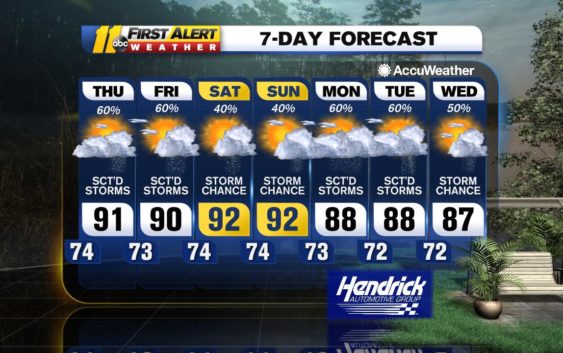
RALEIGH, N.C. (WTVD) — A disturbance has sparked widely scattered storms across central North Carolina. Storms will stick around until sunset, and then rain will clear later this evening.
A front will remain stalled to the north tomorrow into Friday as a weak waves of low pressure track eastward along it. That front combined with warm and humid air will develop scattered to numerous showers. Some of those storms could produce gusty winds.
That front will pull away north of the area, but unsettled weather will stick around through the weekend. We’ll continue to see seasonable high temperatures near 90 degrees.
A dip in the jet stream will increase our rain chances during the start of next week. More rain and clouds will lower highs down the 80s giving us a break from the oppressive heat.
Tropics
Tropical Storm Isaias has officially formed in the Caribbean Sea, according to the National Hurricane Center. This makes Isaias the ninth named storm of the 2020 season.
The latest forecast keeps it as a tropical storm as it tracks towards Florida at 20 mph. As of Thursday evening, North Carolina is one of five states predicted to be in Isaias’ path.
The tropical storm has sustained winds at 50 mph, with gusts reaching up to 65 mph.
Hurricane hunters will fly into the system tomorrow to gain monitor the system closely.
Have a great evening!
-Brittany Bell
Copyright © 2020 WTVD-TV. All Rights Reserved.