- EF-1 tornadoes ripped through Cypress, Waller County areas with winds at more than 100 mph, NWS reports
- Houston-area storm damage updates: Clean up continues after NWS says two EF-1 tornadoes and powerful derecho ripped through SE Texas
- Low risk of damaging winds, hail from Saturday storms
- EF 1 tornadoes ripped through Cypress, Waller County areas at more than 100 mph, NWS reports
- Caddo Mounds State Historic Site to celebrate new visitor center, traditional grass house after 2019 tornado
Isaias now a hurricane; Outer Banks and Hampton Roads near the center in the cone of uncertainty
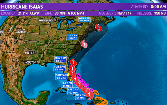
On its projected path, Hurricane Isaias is likely to bring heavy rain, winds, and rough surf to the region.
NORFOLK, Va. — Isaias has strengthened to become the season’s second hurricane.
On Thursday night, Air Force Reserve Hurricane Hunter aircraft data indicated Isaias has maximum sustained winds of 80 miles per hour, with higher gusts. That makes it a Category 1 hurricane.
Hurricane Isaias continues to look like it could threaten Hampton Roads as a hurricane this upcoming Monday or Tuesday. We will know more in the coming days but right now we are smack dab in the middle of the cone of uncertainty.
Hurricane alerts are in place for the Bahamas and areas of the Turks and Caicos are under tropical storm warnings. Hurricane conditions are expected in the Bahamas today. The storm still may strengthen more as it moves near/through the islands of the Bahamas.
Tropical Storm Watches are currently in place for parts of the east coast of Florida.
The current track takes the center of the storm over the Bahamas, northwestward toward the southeast coast of Florida, and then turns it northward toward the southeast United States, and eventually up along the Carolina coast, an all-too-familiar path.
According to the National Hurricane Center, Isaias is expected to be a hurricane on its approach to the Carolina coastline on Monday.
As you can see from the Hurricane Weather Research and Forecasting HWRF) model, it is possible the system could be farther inland from the current NHC forecast. There still remains some question about the exact path, so stay tuned for more updates over the coming days.
DOWNLOAD: 13News Now App
DOWNLOAD: 13News Now Hurricane Guide
There is growing confidence in the current projected path, a track is not uncommon for tropical systems. Just last year Hurricane Dorian followed a similar path near northeast North Carolina and Coastal Virginia.
Of course, each tropical system is unique and small fluctuations in track and intensity can mean big differences in the impacts felt over a given location.
On the current forecast track, possible impacts to the region include heavy rain, strong winds, rough surf, dangerous rip currents, and some beach erosion.
All of this depends on how things develop with this storm, and this could all change, so continue to check back for updates over the coming days.
Hurricane Isaias broke the record as the earliest ninth Atlantic named storm. The previous record-holder was Hurricane Irene, which formed on August 7, 2005.
RELATED: 13News Now Hurricane Guide 2020