- How sewage floods at home turned into nightmares for Raleigh families
- Rock Hill storm damage costs are 'somewhere around $5 million.' That number doesn't include damage to personal property
- Rock Hill storm damage costs are 'somewhere around $5 million.' That number doesn't include damage to personal property
- ‘Somewhere around $5 million’ | Rock Hill officials see major storm damage costs
- The deadliest tornadoes to ever hit Austin
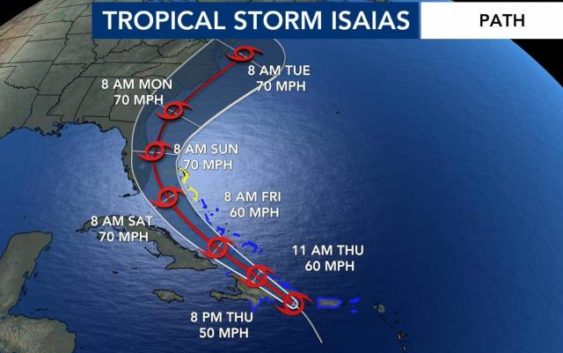
Tropical Storm Isaias update 11 p.m. July 30
The WRAL Severe Weather team is tracking the tropics daily throughout hurricane season with the latest on storm tracks, expected impacts and safety at the coast.
Good afternoon. I’m meteorologist Amy Wilmoth in the WRL Severe Weather Center. Keeping an eye on the tropics, we have an update from the National Hurricane Center. The 11 a.m. update is in. The tropical storm is still has maximum sustained winds at 60 MPH, moving to the northwest at 20 MPH. The circulation, the center, the circulation. Moving over Hispaniola right now. So we do expect some weakening as it moves over land. Hispaniola has mountains with it, so we do expect it to weaken over the next few hours. But then, as it moves back over the warm waters, that could likely strengthen again. Here’s a look at the satellite imagery, and we are starting to see some organization with this, especially the north eastern side of the storm, as it continues to move to the north and west. Here’s a look at the latest track. It takes it through the Bahamas over the weekend and into Florida as well. It does keep the center of circulation just offshore, and that’s not the best news because the temperatures, the water temperatures are very, very warm. The one thing that we have going for us that will likely keep this storm from becoming potentially a hurricane, because we do have some wind shear that it’s going to run into, and that typically tends to make these systems fall apart a little bit. It’s harder for them to get a lot of strength when they’re running into some of that Shirin. It does look like it will run into some wind shear, which is good news but nonetheless says, We get into Monday and Tuesday. That’s when we’re likely to feel the impacts here in North Carolina. The forecast right now has 70 mile per hour wind gusts along the North Carolina coast, and we will have cruise along the coast and we’ll be keeping you updated over the next several days. But it does look like right now that our coast will have impacts Monday into Tuesday. If you’re headed to the coast this weekend, expect some storms. I know a lot of people will probably be heading to the coast to get there. Holmes ready for the storm As it makes its way toward North Carolina, you’ll run into some thunderstorms, but the strongest winds with this system will still be well to the south of North Carolina over the weekend. This is Saturday morning at 10 a.m. So you can see the center of circulation over the northern Bahamas, just off the coast of Florida. And then we continue to go through the weekend and into Tuesday. This is Tuesday morning at 4 30 It’s off the coast of Wilmington at that point. And then as we head Teoh around noon on Tuesday, the senator circulation over the Outer Banks. So most likely, feeling these impacts along the North Carolina coast is we get into Monday and Tuesday still little questionable on the timing of This will definitely have a better handle on the timing and the strength as we get into the next 2 to 3 days. Here are the key points right now it’s interacting with Hispaniola. It’s likely going toe weaken a little bit as it moves over that mountainous terrain. Theo United States will have impacts. The storm reaches Florida late Saturday, and then North Carolina will likely feel those impacts as we get into Monday and Tuesday. Keep it here to W area. We’ll continue updating this video as we get updates from the national hurricane center and will also keep you up to date on Our newscast will have the latest today at noon on Fox 50.