- Flood Watch issued for San Antonio and surrounding areas
- 9-year-old’s heroic act saves parents after Oklahoma tornado: ‘Please don’t die, I will be back’
- Hurricanes beat Islanders to clinch NHL playoff 1st-round series in 5 games
- Drury, Noesen help Hurricanes beat Islanders 6-3 to clinch NHL playoff 1st-round series in 5 games
- Weekend storm damage caused by 2 confirmed tornadoes in Central Texas
Hurricane Isaías grows a little stronger nearing Florida
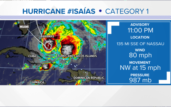
Isaías is a hurricane with 85 mph winds and estimated wind gusts as high as 100 mph. Currently this lopsided storm is over the Bahamas and has turned NW moving around 15 mph. The track is taking it up the east coast of Florida and into the Carolina by Monday and Monday night.
The storm should start to weaken after it brushes Florida. The amount of weakening will depend on how much interaction it has with Florida and the amount of wind shear. The farther west it goes the weaker it will be, the farther east it goes the stronger it will be. So a coastal hugger might be the worst of both with lots of wind and storm surge. The storm will pick up speed and move into the Carolina Monday into Tuesday but be long gone by Tuesday night.
The storm should be weak and moving fast both of which means less rain and not long duration winds. The storm surge might be the worst impact but even that will only last for a few hours.
LOCAL IMPACTS:
For the Charlotte area back to Hickory and Boone we might not even know its out there. We will see some clouds and breezy conditions. The bigger impacts for rain will come from a slow-moving upper low and trough that will be hanging over the region through most of next week.
Stay tuned for later updates and follow up on Social Media for more updates on the storm as it gets closer to the Carolinas. Track forecast updates are coming out every day at 5AM, 11AM, 5PM, and 11PM until the storm is gone.