- $40 million to go to underserved SC counties for Hurricane Helene recovery. Here's what you need to know.
- Family honors Air Force veteran Derwin Anderson Jr. after he died in June flash floods
- City of Wilmington addresses flooding on New Centre Drive
- Harnett County fire: Two homes damaged
- Medical examiner identifies 13th victim from massive flash flood in San Antonio
4 p.m. Isaias forecast update from WRAL Severe Weather Center
The WRAL Severe Weather team is tracking the tropics daily throughout hurricane season with the latest on storm tracks, expected impacts and safety at the coast.
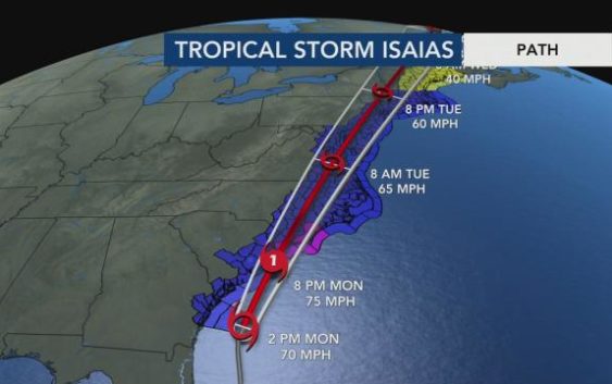
I’m Meteorologist Elizabeth Garden, where the 11 o’clock update from the National Hurricane Center A couple of things have changed for one track looks like it’s slightly further west. Not gonna have a big impact on what we’ll see here. We’ll go over the winds and the rain and when you’ll see all of that in your particular area coming up in just a second biggest thing was we had some counties that were under a tropical storm watch, including Wake County. Those air now all under a tropical storm warning 60 to 70 MPH. Wink us possible for tonight. There’s a look at the new advisory. The center of the storm is about 220 miles Southwestern Myrtle Beach. It is still likely to become a hurricane later today, likely to make landfall near Myrtle Beach again. That’s gonna be that slight westward track versus the 5 a.m. advisory, when 70 MPH is still moving north at 13 MPH bed and take a look at that track, and again you can see at 8 p.m. The hurricane center has it a 75 mile per hour winds, so it may be just before it makes landfall that becomes a hurricane. 74 MPH winds would make it a hurricane washing that storm sitting out over some nice warm water, beginning to strengthen a little bit more satellite image. It still looks a little bit ragged, but some of that warm water that it’s sitting over will help to energize storm and potentially help it to strengthen. So there’s our landfall, probably around nine o’clock, that eight timestamp sitting just barely offshore so officially probably around nine, and it continues to move northward. Our next time stamp is an 8 a.m. on Tuesday, and it’s already up just to the west of Virginia Beach. So this is moving through very quickly. It’s going to purely be an overnight event for us in our area. Let’s take a look. We’ll watch where it’s headed, of course, on a new New York, Boston and in Canada during the day on Tuesday, and this thing is going to fly, and that’s really good news for us. Faster it moves less time, sits here and either continues Teoh pound us with strong winds or with heavy rains. Here’s a look. A tropical storm warning when’s dusting up to 70 MPH, 3 to 6 inches of rain and isolated tornadoes. And we’ve already started to see some of the rain bands coming in today, and we’ll go through that Trackers for you coming up on future cast in just a minute. Also knew with the 5 a.m. advisories isn’t brand new, but hurricane warning in effect for the Wilmington area and several counties surrounding this is where wins, maybe gusting up to 75 MPH, potentially maybe 2 to 4 inches of rainfall and a to four foot storm surge in that area. So not likely to see that hurricane morning extended because of the track of the storm. It’s not headed over to the Outer Banks, so that’s probably as far as our hurricane morning well down in the flood watch, in effect for almost all of North Carolina. There some pockets not included again. 3 to 53 to six inches of rainfall, flash flooding. That’s the kind of flooding where we get this heavy rain really quickly. We see the water rise and sometimes covering roads, but very quickly that water recedes. Taking a look we now we’re starting Teoh. See some hints from the river forecasts that we could see some moderate to possibly low end major flooding on the News River, Clayton and Smithfield. So that’s something that will be washing for especially downstream. Deal. We’re watching the news river in particular for the potential for some flooding. But I’ll tell you, the storm is not going to be anything like Florence or Michael or Matthew where we had, you know, 10 15 20 inches of rain we’re looking at, you know, 3 to 6 inches, maybe some pockets at seven or eight, but those would be very localized. Here’s future cast kicking things off right here. We do have a band, a couple of bands of heavy rain coming on through. We’ll push it ahead to two o’clock and you know how tropical systems are. It’s all bandits that we’ll see ringing on and off the afternoon. Another big band comes around five, but after that that rain starts to become a little more steady. So maybe, you know, fairly light to moderate, and then we’ll have a heavy band aid that comes through when those bands come through. That’s when we’ll have the best chance of seeing some tornadoes possible. And, of course, someone damage. That’s what we see. The strongest wind is within some of those rain bands. One o’clock in the morning, rain is coming down really all across our viewing area, but definitely heaviest. From Raleigh eastward, you can see the center of circulations. We stop things here at 4 a.m. Between Rocky Mount and Golds Broom that that feeling all the rain is north of the centre. Moving on out, Teoh, say 78 o’clock. It’s pretty much over. At that point, they’re still. So maybe some blustery winds is a cloud cover of it. Future cast wants to clear this out. And I mean, we’re really finished with this thing by the middle of the morning. The Storm Prediction Center. Of course, jumping in with that potential for some tornadoes, we have a level to risk. This was updated around mid morning for a little to risk, really along and east of I 95 to a lot of our counties there in that bigger threat for some isolated tornadoes, take a look at our rainfall totals. It’s huge swath right through the middle of our viewing area on and then closer to the coast. But notice how it really tapers off everywhere the outer Banks, that heavy sort of access of heaviest rain there, right along the path of that storm. Really pick it out when you take a look at this rainfall totals. Talk about wind speeds. This is a pretty interesting graphic to watch, too. This is a future cast model. Look at our wind speeds are still in pretty good shape up till about six o’clock, and then after that is that storm starts to move North Room. Really see those winds picking up? So here’s midnight, starting to get into 45 50 MPH winds from Raleigh and Goldsborough southward. After that to get into that potential of maybe a few isolated locations with a 70 mile per hour wind gusts around three on. Then around five o’clock we’re starting back it off again, anywhere from 50 to 60 mile per hour, wind gusts and starting to really take her things up, say Southern pines, back down to about 30 mile an hour. Wind us by 8 a.m. 22 30 40 MPH. When Dustin As that storm system moves on out, it’s gonna be the end of it. So again, a fast mover. We’re not looking at sort of record rainfall totals here, But the bigger issue maybe, and typically inland, the rain is their biggest issue. The flooding. With so many of the storms that we see in this case, it may be more of a wind issue. It’s not gonna be as bad as Fran for those of you who might remember France, But still, we’re gonna see winds gusting up to 60 MPH across parts of our viewing area. It’s gonna knock down some trees. That means you really, really don’t want to be driving after sunset tonight or before some sunrise tomorrow. It could be trees across the road that you’re just not able to see until the last minute trees. They’re gonna fall on houses and cars were going to see some damage. Teoh awnings and porches, Things like that. Shingles. So we’re gonna see some significant wind damage in some places and not just from tornado damage. So that’s gonna be the big thing that we’ll see overnight tonight. Of course, we’ll continue to update this every time we have brand new information for you. With the very latest information you’ll find on TV, we’ll have our noon newscast and then likely will begin our continuing coverage around the middle of the afternoon, potentially around 3 p.m. So make sure that you turn on the TV for the very latest information.