- Seven months after Hurricane Helene, Chimney Rock rebuilds with resilience
- Wildfire in New Jersey Pine Barrens expected to grow before it’s contained, officials say
- Storm damage forces recovery efforts in Lancaster, Chester counties
- Evacuation orders lifted as fast-moving New Jersey wildfire burns
- Heartbreak for NC resident as wildfire reduces lifetime home to ashes
Latest: Isaias weakens to a tropical storm, center is over Wilson County
Get the latest updates on Hurricane Isaias, which is moving north up North Carolina Tuesday morning, bringing heavy rains and strong winds from Raleigh eastward.
Things to know:
- Isaias made landfall as a Cat. 1 hurricane at 11:10 p.m. near Ocean Isle Beach. It was downgraded to a tropical storm at 4 a.m.
- Isaias is expected to move out of North Carolina by 7 or 8 a.m., when weather conditions should start to improve.
- More than 179,000 were without power in North Carolina at 3 a.m., most in Brunswick and New Hanover counties. Duke power outage map.
- The biggest concern in central North Carolina includes flash flooding on roads and strong wind gusts, which could bring down trees and cause power outages.
- Although the storm is passing west of the coast, it is causing storm surge and rough rip currents there.
4:15 a.m.: Interstate 40 is closed in Burgaw due to some flooding on the roads. WRAL News received a tip that there was some water on the highway on U.S. Interstate 1 in Cary.
4:00 a.m.: The Brunswick County Sheriff’s Office shared on Facebook that a large family, including a bassett hound, was rescued from Oak Island. Multiple trees fell in the area, but reports of flooding were minimal.
3:45 a.m.: Isaias has been downgraded from a Cat. 1 hurricane to a tropical storm with maximum sustained winds at 70 mph. The center of circulation was right over Wilson County at 3:45 a.m.
3:30 a.m.: The effects from Isaias stretch as far as Durham, which was under a flood advisory until 6:30 a.m. Between 2 and 3 inches of rain fell in areas of Durham County, and an additonal couple inches could fall before conditions start to improve. Several dozen customers were without power in the Triangle.
3:15 a.m.: While much of North Carolina’s coast has seen mainly wind damage, Myrtle Beach saw significant flooding. A meteorologist in the area posted a video of flooded roads in Garden City, south of Surfside Beach.
3:00 a.m.: Crabtree Creek in Raleigh has risen several inches, but it is not expected to flood Crabtree Valley Mall as it did in past hurricanes. Hurricane Isaias is moving very quickly through the area instead of sitting in one place, dropping inches of rain.
2:55 a.m.: Sampson and Wayne counties have been dropped from the tornado watch. The tornado warning for Northampton County has ended. Subscribe to get WRAL Weather alerts in your area.
2:50 a.m.: WRAL meteorologist Zach Maloch said, while it is still a hurricane, Isaias’ eyewall is weakening as it moves over land. In many areas, wind speeds have decreased, although heavy rain continues to fall.
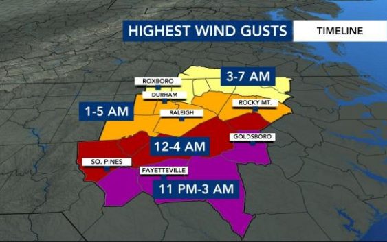
2:40 a.m.: Goldsboro will see the strongest winds before 3 a.m., Wilmoth reports. Areas just east of Wake County are currently seeing the greatest impacts from the storm, and a tornado watch is in in effect until 6 a.m. for that area.
Wilmoth said the Isaias’ center of circulation is just south and west of Rocky Mount.
By 5:30 a.m., the worst conditions will be in the northern part of our viewing area, she said. By 7 a.m., the storm will be moving into Virginia, and we could even see some sunshine in the Triangle. “This is moving very, very quickly,” she said.
2:20 a.m.: A tornado has touched down in Northampton County, Kat Campbell confirmed. Residents in Conway and Edwards Crossroads will be affected in a matter of minutes and need to take shelter immediately, Campbell said.
Subscribe to get WRAL Weather alerts in your area.
2:15 a.m.: Gene Booth, Emergency Director in Fayetteville, said the city is faring well, and flooding has not been a major issue there. Several more inches of rain are expected to fall before the morning is over.
2:00 a.m.: Hurricane Isaias remains a Cat.1 hurricane with winds at 75 mph. It was moving northeast at 23 mph up the Interstate 95 corridor and is approaching the Goldsboro area.
Goldsboro, Fayetteville and Raleigh have seen almost 2 inches of rain already. A flash flood watch remains in effect for the entire viewing area. The highest rainfall totals, over 4 inches, are expected in Rocky Mount. The flood risk is high in Raleigh, where more than 3 inches of rain are expected by Tuesday afternoon.
WRAL meteorologist Aimee Wilmoth said Avent Ferry Road in Raleigh was already starting to see some flash flooding. WRAL Aaron Thomas is tracking road conditions in Raleigh, where the main concern is consistent rain and flash flooding.
1:42 a.m.: A tornado warning has been issued for the southeastern part of Northampton County until 2:15 a.m. It was currently the only tornado warning issued in the WRAL viewing area as Hurricane Isaias continues to impact the state. Areas of Rich Square and Woodland were expected to feel the impacts of the tornado.
1:32 a.m.: North Carolina Emergency Management reports a tornado touched down in Bertie County near Windsor. WRAL meteorologist Kat Campbell also reports the WRAL Debris Detector picked up on activity just west of the Windsor area. The tornado was moving at 40 mph.
1:16 a.m.: There are now over 207,000 power outages across the state, according to the N.C. Department of Public Safety. Most are in the areas of New Hanover and Brunswick counties. WRAL’s Bryan Mims also reports at least 200 without power in the Fayetteville area. Updated information on power outages can be found on the NCDPS website.
12:56 a.m.: The tornado watch no longer includes many of the southern North Carolina counties. It does continue for Sampson, Wayne, Edgecombe, Nash and Wilson counties along with all areas east of those locations. Those tornado watches will run until 6 a.m., meteorologist Kat Campbell said.
12:38 a.m.: The N.C. Department of Public Safety is reporting over 132,000 power outages across the state. The majority of them are right in the area where Hurricane Isaias made landfall.
12:32 a.m.: Officials with the Ocean Isle Fire Department confirmed to WRAL there were six houses on fire with no injuries. They were still trying to work on a way to get there to render aid.
11:50 p.m.: A flash flood warning has been issued for Cumberland County, Harnett County, Johnston County, Sampson County, and Wayne County until 5:45 a.m. on Tuesday. Flash flood warnings were also issued for Wake, Wilson, Nash, Franklin and Edgecombe counties until 6:15 a.m. The National Weather Service says one to two inches of rain have already fallen in the area and more heavy rain is ongoing. Rainfall rates are expected to increase to one to two inches per hour, with higher rates possible, and up to five inches of rain could fall in the warned area. It is best to stay home, but if you must drive, do not attempt to drive through flooded roads.
11:43 p.m.: According to Duke Energy, New Hanover County now reports almost 65,000 customers without power — nearly half of the customers served in New Hanover County by Duke Energy.
11:40 p.m.: WRAL Meteorologist Zach Maloch is in the WRAL Storm Tracker in New Hanover County where he witnessed some large trees down in the roadway on US-74.
11:34 p.m.: There were reports of several fires on Oak Island and Ocean Isle Beach late Monday night. Ed Conrow with Brunswick County Emergency Management said officials were trying to respond but the persistent rain and flooding was making it hard. They were not aware of anyone trapped but they do know people were stuck on the islands. They said they may have to wait until the morning before they can respond.
Ocean Isle Beach Mayor Debbie Smith told NBC affiliate WECT there were at least three fires on Driftwood Drive and another on East 4th Street. It was unclear the extent of damage at those structures.
")
11:31 p.m.: The National Weather Service has issued a tornado warning for Craven County and Pamlico County. A possible tornado was located over Olympia, or near James City, and was moving north at 55 mph. Locations impacted include Askins, Olympia, Ernul, and Fairfield Harbour. The warning lasts until 11:45 p.m.
11:20 p.m.: The National Hurricane Center says Hurricane Isaias made landfall at Ocean Isle Beach at 11:10 p.m. as a Category 1 hurricane with sustained winds of 85 miles per hour.
11:17 p.m.: A tornado warning has been issued for Pasquotank County and Perquimans County in northeastern North Carolina until 11:45 p.m. According to the National Weather Service, a possible tornado was located seven miles south of Weeksville and was moving northwest at 35 miles per hour. The storm will impact Nixonton, Elizabeth City, Bob White Fork, Jacocks, Rabbit Corner, Stevenson Point, Symonds Creek, Listers Corner, Woodville, and Forestburg.
11:13 p.m.: New Hanover County is reporting 20,000 customers without power right now, according Duke Energy. In addition, over 3,000 customers in Sampson County are without power, most of which are in the Roseboro, Autryville, and Salemburg communities.
11:03 p.m.: The National Hurricane Center has issued a Storm Surge Warning from the Ocracoke Inlet to the North Carolina-Virginia state line. This includes the Pamlico and Albemarle Sounds, including the Neuse and Pamlico Rivers.
10:58 p.m.: WRAL Meteorologist Kat Campbell says Frying Pan Shoals Tower recorded a wind gust of 102 miles per hour.
10:56 p.m.: According to Brunswick County Emergency Services Director Ed Conrow, they are beginning to receive more damage reports as the eye wall moves onshore in the county. Conrow said there are at least 23,000 residential power outages reported.
10:53 p.m.: The latest update from the National Hurricane Center keeps Hurricane Isaias as a Category 1 storm with maximum sustained winds of 85 mph. It has picked up speed, moving north northeast at 22 mph. WRAL Meteorologist Kat Campbell says the eye of the storm is moving ashore in Brunswick County right now.
10:47 p.m.: WRAL Meteorlogist Zach Maloch is in Brunswick County in the WRAL Storm Tracker where they have recorded a wind gust of 72 mph.
10:38 p.m.: Conditions have gone calm at Ocean Isle Beach in Brunswick County as the eye approaches the southeastern part of the state. Landfall is when the center of the storm comes on land, but parts of the North Carolina coast are already experiencing calm conditions in the eye of the hurricane.
10:30 p.m.: Here’s a look at the latest power outage numbers from Duke Energy:
- Durham: 638
- Wake: 603
- Chatham: 157
- Granville: 117
- Johnston: 34
There are many more power outages in the southeast part of North Carolina:
- New Hanover: 1,628
- Brunswick: 1,595
- Columbus: 412
- Bladen: 80
- Pender: 28
- Robeson: 28
10:15 p.m.: WRAL reporter Amanda Lamb reports that the intracoastal waterway has topped the sea wall in Wrightsville Beach. Lamb said the water level is usually about two feet below the sea wall.
9:59 p.m.: The National Weather Service has issued a tornado warning for New Hanover County, Pender County, Brunswick County, and Columbus County in the southeastern part of North Carolina until 10:30 p.m. The storm was located over Silver Lake, or near Wilmington, and is moving northwest at 60 mph. Locations impacted include Hightsville, Wilmington International Airport, UNC-Wilmington, Bishop, Leland, Phoenix, Wrightsboro, Cape Fear Community College, Northwest, Montague, The Borough, Long Creek, Currie, Sandy Creek, Navassa, Belville, New Hanover Regional Medical Center, and Cape Fear Hospital
9:55 p.m.: A power outage has been reported in northern Wake County along Ligon Mill Road, just south of US-1A. The outage is affecting about 300 customers. The cause of the outage is not known and there is no estimated restoration time.
9:46 p.m.: Frying Pan Shoals Tower, located about 30 miles off the coast of North Carolina near the Cape Fear region, recorded a 93 mph wind gust at 9:24 p.m., according to WRAL Meteorologist Kat Campbell.
9:45 p.m.: Ocean Isle Beach in Brunswick County is beginning to see a storm surge along the canal side of the island.
9:37 p.m.: The National Weather Service has issued a tornado warning for Washington County, Hyde County, and Tyrrell County in eastern North Carolina until 10 p.m. A possible tornado was located over Alligator Lake, or about 25 miles southeast of Plymouth. The storm is moving north at 35 mph. Locations impacted include Woodley, Pleasant Grove, Westover, Scuppernong, Phelps Lake, Pungo Lake, Alligator Lake, Roper, and Creswell.
9:22 p.m.: Over 150 Duke Energy customers are without power in Oxford. Over 100 customers along NC-96 on the northwest side of Oxford are without power, while about 50 customers are without power near downtown between Lewis Street and Martin Luther King Jr. Avenue.
9:08 p.m.: The National Weather Service says it has a report of a roof blown off a house at Bald Head Island. There was a report of a tornado on the ground at Bald Head Island earlier in the evening.
9:05 p.m.: The National Hurricane Center says Hurricane Isaias has strengthened and now has maximum sustained winds of 85 mph.
9:00 p.m.: Duke Energy is reporting a major outage of nearly 1,500 customers in the area of Southport, Caswell Beach, and Bald Head Island in the southeastern part of the North Carolina coast. The estimated restoration time is 11:59 p.m. on Tuesday, Aug. 4.
8:55 p.m.: A new tornado warning has been issued for Bladen County, Brunswick County, Columbus County, New Hanover County, and Pender County until 9:15 p.m. A possible tornado was located over Phoenix or near Leland, moving northwest at 50 mph. Locations impacted include The Borough, Montague, Riegelwood, Delco, Sandyfield, Point Caswell, Rooks, Currie, Kelly, Rowan, Sandy Creek, Navassa, Atkinson, and East Arcadia. This includes I-40 and US-74.
8:53 p.m.: A tornado watch has been issued for a large portion of eastern North Carolina. The watch includes Sampson County, Wayne County, Wilson County, Nash County, Edgecombe County, Halifax County, and Northampton County in the WRAL viewing area. It also includes all counties east of those counties to the Outer Banks. The watch is in effect until 6 a.m. on Tuesday.
8:51 p.m.: Mayor Larry Dobbins of Spring Lake has declared a state of emergency due to Hurricane Isaias.
8:49 p.m.: Mayor Mitch Colvin has declared a state of emergency for the city of Fayetteville in Cumberland County.
8:47 p.m.: Duke Energy is reporting a power outage on the west side of Pittsboro in Chatham County, which was caused by fallen tress or limbs. The outage is impacting 148 customers and the estimate restoration time is 12:15 a.m. on Tuesday.
8:35 p.m.: The National Weather Service reports a tree is down in the road at the intersection of Calvary Drive and Green Road in Wake County. WRAL reporter Aaron Thomas reports a tree fell on Cowper Drive near Glenwood Avenue in Raleigh too. Emergency crews were on the scene cleaning up.
8:29 p.m.: Another tornado warning has been issued for Brunswick County and New Hanover County until 9 p.m. The possible tornado was located about 7 miles south of Batarora or 12 miles west of Leland, and was moving northwest at 50 mph. Locations impacted include Honey Island, Delco, Freeman, Riegelwood, Sandy Creek, Bolivia, Brunswick Novant Medical Center, Dosher Memorial Hospital, and Varnamtown.
8:25 p.m.: Nearly 400 people are without power near the Orange & Durham County line near I-40, Erwin Road, and Whitfield Road. Duke Energy says fallen trees are to blame.
8:23 p.m.: The number of power outages in Wake County has declined. At one time, more than 3,000 Duke Energy customers in Wake County were without power, but that number is now just over 400. Most of those power outages are in Garner, south of Timer Drive near NC-50, or close to Lake Benson. Duke Energy says fallen trees caused the outage.
8:13 p.m.: Another tornado warning has been issued by the National Weather Service, this one for Brunswick County, Columbus County, and New Hanover County. The storm capable of producing a tornado was located near Boiling Spring Lakes, or near Oak Island, and is moving northwest at 50 mph. Locations impacted include Mills Creek, Brunswick County Community Colege Main Campus, Winnabow, Town Creek, Bishop, Batarora, Honey Island, Freeman, Delco, and Riegelwood. The tornado warning is in effect until 8:45 p.m.
8:06 p.m.: The National Weather Service has issued a tornado warning for Brunswick County and Columbus County in North Carolina and Horry County in South Carolina until 8:30 p.m. A storm capable of producing a tornado was located near Pireway and moving northwest at 20 mph. Locations impacted include Longs, Bughill, Dulah, Loris, Bethel, Goretown, and Mollie. This includes US-17 in Brunswick County between mile markets 1 and 5.
7:52 p.m.: The National Weather Service has issued a tornado warning for Brunswick County until 8:15 p.m. A storm capable of producing a tornado was located near Yaupon Beach and was moving northwest at 45 mph. Areas impacted include Oak Island, Ocean Crest Pier, St. James, Long Beach, Brunswick Community College Main Campus, and Supply.
7:50 p.m.: The National Hurricane Center says that Isaias has been upgraded to a Category 1 hurricane with maximum sustained winds of 75 miles per hour.
7:35 p.m.: WRAL is beginning to get reports of some branches coming down in parts of the Triangle. WRAL reporter Aaron Reporter is in Wendell in Wake County where a large branch came down. A viewer also sent a photo of a large branch down on Capital Boulevard near Calvary Drive in Raleigh.
7:30 p.m.: Power outages continue to pop up in the Triangle. The number of power outages has dropped to around 2,000, but there is a large outage in Garner south of Timber Drive and east of NC-50, near Lake Benson. There is no information available about the cause of the outage, but the estimated restoration time is 10:15 p.m., according to the Duke Energy Outage Map. There is a smaller outage reported in Clayton off Barber Mill Road near Amelia Church Road.
7:24 p.m.: WRAL Meteorologist Kat Campbell says the center of Tropical Storm Isaias passed over a buoy, which recorded a pressure lower than the pressure the National Hurricane Center observed during its 5 p.m. advisory. This could mean the storm is strengthening. Wave heights are beginning to rise off the North Carolina coast too. One buoy recorded a wave height of over eight feet off the coast of Wilmington.
6:58 p.m.: Wake County announced some facilities will open later than normal on Tuesday due to Tropical Storm Isaias. Solid waste facilities will open at 9 a.m., Wake County parks will open at 10 a.m., and Wake County libraries will make a decision about when to reopen in the morning.
6:55 p.m.: Things are calm right now in the Dare County town of Manteo, where they’ve not seen any rain from Tropical Storm Isaias yet, according to WRAL reporter Rosalia Fodera.
6:46 p.m.: Tropical Storm Isaias is expected to bring high winds and heavy rains inland overnight. According to WRAL meteorologist Kat Campbell, the Sandhills region could see high winds as early as 11 p.m., while the Triangle will likely see the high winds begin around 1 a.m.
6:30 p.m.: WRAL reporter Amanda Lamb is in Wrightsville Beach in New Hanover County where she reports rain and wind is beginning to pick up a little bit. Even so, visitors are not leaving the beach. There is a voluntary evacuation order in place for tourists.
6:27 p.m.: Over 3,000 people are without power in Wake County, most of them in the MacGregor Downs area between US-64 and Cary Parkway. Duke Energy’s website says the outage was caused by falling trees or limbs.
6:25 p.m.: Surf is picking up in Ocean Isle Beach in Brunswick County. At the east end of the island, the water is approaching oceanfront homes.
6:15 p.m.: WRAL meteorologist Zach Maloch is in Myrtle Beach, S.C., with the WRAL Storm Tracker. He’s monitoring the threat for storm surge, which could be as high as 3-6 feet in some areas, particularly south-facing beaches. A storm surge warning is in effect.
6:10 p.m.: Horry County, S.C., where Myrtle Beach is located, is under a Hurricane Warning and a Storm Surge Warning, but the Grand Strand is not shut down to tourists. There are no evacuation orders in place. WRAL anchor Kathryn Brown is in Myrtle Beach and spoke with some tourists about their plans.
5:48 p.m.: President Donald Trump says he has issued emergency declarations for North Carolina, South Carolina, and Florida due to Tropical Storm Isaias. The Federal Emergency Management Agency is already on the ground, Trump said.
5:30 p.m.: Some outer bands are beginning to move through the Triangle area. WRAL reporter Cullen Browder is in Johnston County where heavy rain and gusty winds were witnessed in one of the bands. There have been no reports of any damage in the Triangle.
4:58 p.m.: The Fayetteville Public Works Commission is asking customers to be prepared for power outages beginning tonight. “PWC crews will be standing by and will work to restore power while conditions are safe. Once Isaias has passed through, we will begin full restoration Tuesday morning,” PWC said in a statement. PWC also said that additional steps and precautions due to COVID-19 could cause outages to last slightly longer.
4:52 p.m.: A tornado watch has been issued for Brunswick County, Columbus County, Duplin County, New Hanover County, Pender County, and Sampson County until 2 a.m. Tuesday. The threat of tornadoes will increase as Tropical Storm Isaias approaches North Carolina.
4:45 p.m.: The latest information from the National Hurricane Center shows Tropical Storm Isaias remains a tropical storm with maximum sustained winds of 70 miles per hour. The storm is still expected to make landfall near Myrtle Beach as a Category 1 hurricane later tonight.
4:22 p.m.: Wayne County has opened two emergency shelters due to Isaias. The shelters will open at 7 p.m. and are located at Meadow Lane Elementary School in Goldsboro and Spring Creek Middle School in Seven Springs. Shelter capacity will be reduced due to COVID-19 and health screenings will be conducted. Face coverings are highly recommended. Pets are not allowed at either shelter.
4:20 p.m.: Meteorologist Kat Campbell says a band of heavy rain is moving west towards Fayetteville and Johnston County. It has a lot of lightning and could have winds of 50 mph. In addition, the Storm Prediction Center has indicated a tornado watch will likely be issued soon for portions of eastern North Carolina.
4:15 p.m.: Duplin County has opened two emergency shelters as Tropical Storm Isaias approaches. The locations are North Duplin Elementary in Mount Olive and James Kenan High School in Warsaw. Pets are not allowed, so they must be dropped off at the county animal shelter. COVID-19 screening will take place.
3:55 p.m.: Rain has started falling in Atlantic Beach, N.C., according to WRAL reporter Joe Fisher. Some people were on the beach earlier in the day on Monday, but people have started to move indoors.
3:50 p.m.: Brunswick County has declared a state of emergency. The state of emergency means there is a voluntary evacuation of low-lying and flood-prone areas in unincorporated areas of the county, as well as anyone who lives in a mobile home. There will be a curfew in place from 9 p.m. Monday until 6 a.m. Tuesday. Two shelters of last resort have been opened at Cedar Grove Middle School and Town Creek Middle School.
3:45 p.m.: Myrtle Beach is bracing for landfall of Tropical Storm Isaias later tonight, but Kathryn Brown reports businesses have not boarded up, sandbags are not out in the streets, and no evacuation orders are in place. She said many vacationers she spoke to hope the storm blows through the area tonight with minimal damage and they’re able to salvage the rest of their vacations starting Tuesday.
3:30 p.m.: Chapel Hill-Carrboro City Schools will not operate its Food for Students program on Tuesday due to Isaias. Instead, students received extra meals on Monday that they can use on Tuesday. All district facilities will be closed on Tuesday as well.
3:25 p.m.: We’re monitoring the conditions in Myrtle Beach, S.C., where Tropical Storm Isaias may make landfall around 9 p.m. tonight.
3:18 p.m.: WRAL Meteorologist Kat Campbell says the worst conditions from Isaias will occur overnight Monday into Tuesday morning. Areas from Raleigh east are under a tropical storm warning and could see sustained tropical storm force winds, flooding, and tornadoes.
3:13 p.m.: The Town of Hope Mills has declared a state of emergency due to Tropical Storm Isaias.
3:00 p.m.: Gov. Roy Cooper is holding a press conference about state preparations for Tropical Storm Isaias. Cooper said dangerous conditions are expected in North Carolina, including hurricane and tropical storm force winds, tornadoes, and flooding. “That status or category of a storm can be misleading. Whether it’s labeled a tropical storm or a hurricane, you should take this storm seriously,” Cooper said, adding that inland areas are also at risk.
2:43 p.m.: Johnston County Public Schools announced that all Summer Feeding Sites will be closed on Tuesday due to Tropical Storm Isaias. In addition, all voluntary athletic workouts are canceled.
2:32 p.m.: Rocky Mount has declared a state of emergency ahead of Tropical Storm Isaias, but there is no curfew in place. Sandbags are available at the Rocky Mount Sports Complex for residents and businesses who may experience flooding with a limit of five sandbags per person.
2:30 p.m.: Raleigh Mayor Mary Ann Baldwin is urging residents to remember to follow coronavirus safety guidelines during Tropical Storm Isaias. Baldwin said if you must leave your home for safety reasons, it is best to stay with family members or a friend instead of going to a shelter, due to the pandemic.
2:20 p.m.: All government offices in Wayne County will be closing at 4 p.m. today due to Tropical Storm Isaias.
2 p.m.: Tropical Storm Isaias has maximum sustained winds of 70 mph and is tracking north at 15 mph. The storm is 325 miles south-southwest of Raleigh and expected to make landfall near Myrtle Beach around 9 p.m.
1:30 p.m.: Ferry operation to Ocracoke Island was suspended Monday afternoon and will only resume once conditions make it safe.
Since Friday, 3,538 people and 1,710 vehicles left Ocracoke on the Hatteras, Cedar Island and Swan Quarter ferry routes.
1 p.m.: Community colleges in Nash, Sampson and Wilson counties canceled classes scheduled Monday afternoon and evening ahead of Tropical Storm Isaias. Fayetteville Technical Community College will also close early Monday.
In Edgecombe and Nash counties, district courts will be closed Tuesday.
11 a.m.: The National Weather Service issued a tropical storm warning for the eastern half of North Carolina Monday morning, a swath of counties stretching from the Triangle to the coast. Over the next 36 hours, communities in the warned area could see wind gusts of up to 70 mph.
The Triangle and communities inland are expected to bear the brunt of Isaias Monday night and into Tuesday, with the highest winds and heaviest rain coming overnight.
“There will be trees down, and there will be power outages,” said WRAL meteorologist Aimee Wilmoth. “This is going to be pretty dangerous since it is happening while people are sleeping.”
Isaias, with winds of up to 70 mph, was still a tropical storm Monday morning, but it was expected to regain hurricane strength by afternoon before a forecast landfall near Myrtle Beach around 9 p.m.
Storm surge warnings are in effect for the entire coast of North Carolina.