- Seven months after Hurricane Helene, Chimney Rock rebuilds with resilience
- Wildfire in New Jersey Pine Barrens expected to grow before it’s contained, officials say
- Storm damage forces recovery efforts in Lancaster, Chester counties
- Evacuation orders lifted as fast-moving New Jersey wildfire burns
- Heartbreak for NC resident as wildfire reduces lifetime home to ashes
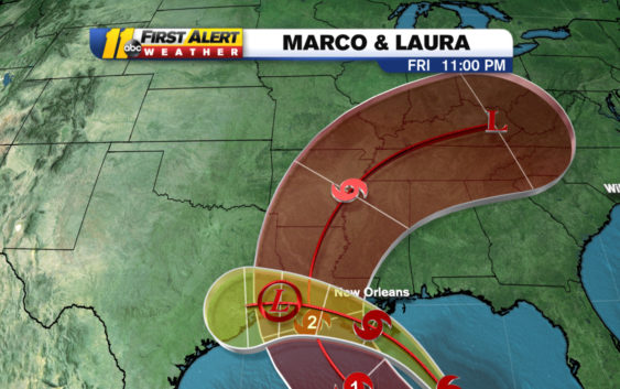
Marco weakens back to tropical storm as Tropical Storm Laura grows stronger in the Atlantic Ocean

Fujiwhara effect: Can 2 hurricanes merge into a megastorm?
Tropical Storm Marco currently has maximum sustained winds of 70 miles per hour, with gusts reaching up to 85 miles per hour. The storm is moving north-northwest through the Gulf of Mexico at 12 miles per hour.
Laura gains some strength as Marco weakens below hurricane status, becoming a tropical storm once again. Tracking it all on @ABC11_WTVD at 11.
— Robert Johnson (@RobJohnsonABC11) August 24, 2020
Marco is expected to make landfall on the Louisiana coast late Monday into early Tuesday.
Tropical Storm Laura is currently hovering over Cuba. Some land interaction could limit strengthening but Laura is now expected to make landfall as a Category 2, potentially as a Category 3 hurricane close to the same area as Marco.
Laura now has maximum sustained winds at 65 miles per hour with gusts up to 70 mph and is moving west-northwest at 21 mph.
Storm Ready 2020: Preparing in a Pandemic
KEY POINTS:
- Marco will make landfall Tuesday and Laura will make landfall Wednesday.
- This could be the first time we have two hurricanes in the Gulf.
- There will be no direct impacts to North Carolina.
Copyright © 2020 WTVD-TV. All Rights Reserved.