- EF-1 tornadoes ripped through Cypress, Waller County areas with winds at more than 100 mph, NWS reports
- Houston-area storm damage updates: Clean up continues after NWS says two EF-1 tornadoes and powerful derecho ripped through SE Texas
- Low risk of damaging winds, hail from Saturday storms
- EF 1 tornadoes ripped through Cypress, Waller County areas at more than 100 mph, NWS reports
- Caddo Mounds State Historic Site to celebrate new visitor center, traditional grass house after 2019 tornado
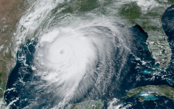
Hurricane Laura now an 'extremely dangerous' Category 4 storm off the Texas, Louisiana coasts | Watch Live
“Unsurvivable storm surge with large and destructive waves will cause catastrophic damage,” the hurricane center warns.
HOUSTON — Residents in far Southeast Texas and western Louisiana are bracing for the worst of the impacts from Hurricane Laura, which is forecast to be a major hurricane at landfall late tonight into early Thursday morning.
The hurricane will bring with it a deadly storm surge, and rescuers will not be able to reach those who choose to not evacuate from areas like Port Arthur, state leaders warn.
LIVE VIDEO NOW: We are streaming live coverage from our sister station KBMT in Beaumont in the video player on this page
In its 1 p.m. update Wednesday, the National Hurricane Center said Laura had become a Category 4 storm with max sustained winds at 140 mph.
“Catastrophic storm surge, extreme winds and flash flooding is expected along the northwest Gulf Coast tonight. Only a few hours remain to protect life and property,” the NHC warned residents of the eastern Texas and western Louisiana coasts earlier in the morning. “Unsurvivable storm surge with large and destructive waves will cause catastrophic damage from Sea Rim State Park, Texas, to Intracoastal City, Louisiana, including Calcasieu and Sabine Lakes. This surge could penetrate up to 30 miles inland from the immediate coastline.”
The worst of Laura’s impacts will be well east of Houston, but we can expect strong, tropical storm-strength wind gusts tonight that could knock out power for some in our area. Scroll down in this story to see the wind gust forecast map.
WHY IT WON’T TURN TOWARD HOUSTON: Experts say it’s unlikely
FORECAST TRACK: View Laura spaghetti models and forecast cone updates
Where is Hurricane Laura going?
The National Hurricane Center’s latest track for Hurricane Laura has it making landfall, likely as a Category 3 or Category 4 hurricane. The models are coming to an agreement about where it will come ashore, and it looks to be right along the Louisiana-Texas border. The forecast track has remained mostly the same for the past 24 hours.
For now, in Houston we should stay prepared but can also begin to send our support, prayers and thoughts to our neighbors to the east. This includes the Port Arthur, Beaumont and Lake Charles areas.
Laura is expected to become a Category 4 storm later today, which means winds will be at least 130 mph. The National Hurricane Center believes just before landfall, Laura may weaken back to a Category 3, which is still a major hurricane.
Where is Hurricane Laura now?
As of 1 p.m., Laura is about 200 miles from Port Arthur and 200 miles from Lake Charles, moving northwest at 16 mph.
Right now, new forecast cones come out every six hours. The 10 p.m. update kept the path in nearly the same spot as the 4 p.m. update – as did Wednesday’s 4 a.m. and 10 a.m. updates. The cone is getting narrower the closer the hurricane gets to shore, which means the Houston area is no longer in the cone of uncertainty.
All communities inside the cone should remain alert and watch for updates through landfall. The KHOU 11 Weather Team is monitoring for any potential shift to the west, as that would mean a greater storm surge for our coastal communities.
What is the danger from Hurricane Laura?
Storm surge is among the worst of the dangers followed by the wind. Yes, there will be rain, but this will not be a Harvey-like flooding event. In Houston, at this point, we may not get much rain at all. The farther east you go toward Beaumont, the worst the weather and storm surge will be.
If the current forecast track holds true, impacts to the Houston area could be minimal, as you can see in this total rainfall image:
While we won’t get hurricane strength winds in Houston, we can expect strong wind gusts capable of knocking out power in some areas tonight into tomorrow morning.
We can expect wind gusts exceeding 20 to 30 mph in the early-morning hours Thursday:
Galveston can still expect about a five foot storm surge (well within the limits of the seawall) while closer to Beaumont and into Lake Charles there will be about a 10 foot storm surge:
A surge could penetrate up to 30 miles inland from the southwest Louisiana coastline and far southeastern Texas.
Hurricane-force winds are expected Wednesday night in the warning area from San Luis Pass to west of Morgan City, Louisiana. The strongest winds near the eye wall will occur somewhere in that area.
Damaging wind and gusts are expected to spread well inland into parts of eastern Texas and western Louisiana early Thursday.
There’s also the possibility of widespread flash flooding along small streams and roadways in far east Texas, Louisiana and Arkansas.
The hurricane will not linger and should be cleared of the landfall area after about 12 hours.
Hurricane warning and storm surge warnings
Hurricane watches and warnings have been posted all along the Houston area.
Details: A Tropical Storm Warning is in effect for Fort Bend, Grimes, Houston, Inland Brazoria, Inland Harris, Madison, Montgomery, San Jacinto, Trinity, Walker, and Waller – A Tropical Storm Warning and Storm Surge Watch are in effect for Brazoria Islands – A Storm Surge Warning and Hurricane Warning are in effect for Chambers, Coastal Galveston, Coastal Harris, Galveston Island and Bolivar Peninsula, and Southern Liberty – A Hurricane Warning is in effect for Inland Galveston, Northern Liberty, and Polk – A Storm Surge Warning and Tropical Storm Warning are in effect for Coastal Brazoria.
From the NHC: “A Storm Surge Warning means there is a danger of life-threatening inundation, from rising water moving inland from the coastline, during the next 36 hours in the indicated locations. This is a life-threatening situation. Persons located within these areas should take all necessary actions to protect life and property from rising water and the potential for other dangerous conditions. Promptly follow evacuation and other instructions from local officials.”
“A Hurricane Warning means that hurricane conditions are expected somewhere within the warning area. A warning is typically issued 36 hours before the anticipated first occurrence of tropical-storm-force winds, conditions that make outside preparations difficult or dangerous. Preparations to protect life and property should be rushed to completion.”
Key messaging / 10 a.m. Aug. 26 update from the National Hurricane Center:
1. Unsurvivable storm surge with large and destructive waves will cause catastrophic damage from Sea Rim State Park, Texas, to Intracoastal City, Louisiana, including Calcasieu and Sabine Lakes. This surge could penetrate up to 30 miles inland from the immediate coastline. Only a few hours remain to protect life and property and all actions should be rushed to completion.
2. Hurricane-force winds are expected tonight in portions of the hurricane warning area from San Luis Pass, Texas, to west of Morgan City, Louisiana, with catastrophic wind damage expected where Laura’s eyewall makes landfall. Hurricane-force winds and widespread damaging wind gusts will spread well inland across portions of eastern Texas and western Louisiana early Thursday.
3. Widespread flash flooding along small streams, urban areas, and roadways is expected to begin this afternoon into Thursday from far eastern Texas, across Louisiana and Arkansas. This will also lead to minor to isolated moderate freshwater river flooding. The heavy rainfall threat and localized flash and urban flooding potential will spread northeastward into the middle-Mississippi, lower Ohio and Tennessee Valleys Friday night and Saturday.
Make sure you’re prepared for a hurricane
It’s way too early to know the exact intensity and track of Laura, but the one thing you can count on — you’ll be better off if you’re prepared.
Here is a list of important items you should have at home or take with you if you evacuate:
- Water – at least 1 gallon daily per person for 3-7 days; also fill bathtub and other containers; Gator Aid is good to fend off dehydration
- Food – at least enough for 3-7 days; non-perishable packaged or canned food; juices; foods for infants or elderly family members; snack foods; food for special diets
- Non-electric can opener
- Cooking tools, fuel
- Paper plates and cups, plastic utensils
- Bedding: Blankets, Pillows, etc.
- Clothing
- Rain gear
- Sturdy shoes
- First Aid Kit, Medicines, Prescription Drugs
- Toilet paper, paper towels, trash bags
- Toiletries, hand sanitizer, hygiene items, moisture wipes, dry shampoo
- Flashlight, batteries, lantern
- Radio: Battery operated and NOAA weather radio
- Telephones: Fully charged cell phone with extra battery; chargers; traditional (not cordless) telephone set
- Cash (with some small bills) and Credit Cards: Banks and ATMs may not be available for extended periods
- Important documents: Place in a waterproof container or watertight resealable plastic bag: Should include insurance, medical records, bank account numbers, Social Security card, prescriptions, etc.
- Tools: Keep a set with you during the storm
- Gas: Fill up your vehicles several days before landfall is expected; Gas stations could lose power during a storm and supply trucks may not be able to reach the area
- Pet care items: Proper identification, immunization records, medications, ample supply of food and water; a carrier or cage; muzzle and/ or leash
- Bleach without lemon or any other additives
- Fire extinguisher
- Mosquito repellent
- Keys
- Toys, books and games for children
- Duct tape
- Cell Phone charging stations – locations where you can charge mobile devices