- EF-1 tornadoes ripped through Cypress, Waller County areas with winds at more than 100 mph, NWS reports
- Houston-area storm damage updates: Clean up continues after NWS says two EF-1 tornadoes and powerful derecho ripped through SE Texas
- Low risk of damaging winds, hail from Saturday storms
- EF 1 tornadoes ripped through Cypress, Waller County areas at more than 100 mph, NWS reports
- Caddo Mounds State Historic Site to celebrate new visitor center, traditional grass house after 2019 tornado
Hurricane Laura strengthens to Cat. 3, 'deadly storm surge' expected in Louisiana
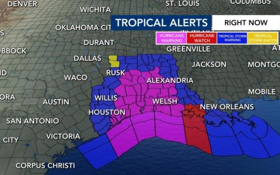
Hurricane Laura is intensifying rapidly and could become a devastating Category 4 storm by Wednesday afternoon.
Laura, a Cat. 3 storm as of the 8 a.m. update from the National Hurricane Center, is forecast to make landfall halfway between New Orleans and Houston, somewhere along the Texas-Louisiana line, Wednesday night. Whether it’s a Cat. 3 or a Cat. 4 storm when it makes landfall, it will bring life-threatening conditions to the Gulf States, according to WRAL meteorologist Elizabeth Gardner.
Gardner said possible storm surge up to 14 feet and the flooding it produces will be deadly in Louisiana and Texas, and strong winds could damage buildings. Between 4 to 8 inches of rain are likely, with 12 inches possible.
“In Louisiana, so much of that coast is at sea level – it’s flat – so it’s going to be devastating for them,” Gardner said.
While impacts from the large storm could stretch from Texas to Florida panhande, Louisiana, the victim of Hurricane Katrina in 2005, will likely get the brunt of the storm, according to Gardner.
More than 385,000 residents were told to flee the Texas cities of Beaumont, Galveston and Port Arthur, and another 200,000 were ordered to leave low-lying Calcasieu Parish in southwestern Louisiana


The areas within the storm’s path that have issued mandatory evacuation orders include Port Arthur, Texas, which has the nation’s largest oil refinery, and Cameron Parish, Louisiana, just across the state line. Oil and gas companies have also evacuated workers from offshore production platforms in the Gulf of Mexico.
North Carolina won’t be impacted by Laura apart from some rain coming our way next weekend, Gardner said.
Why Laura is gaining strength over the Gulf
Water temperatures in the Gulf of Mexico are warm, with temperatures in the mid-80s, which will likely cause Laura to strengthen as it gets closer to the U.S.
“Warm sea surface temperatures really help these storms fuel and intensify,” WRAL Peta Sheerwood said.
This year’s Atlantic hurricane season has been busy, with record-setting storms. Tropical Storm Marco was the earliest named M storm in recorded history, according to WRAL meteorologist Mike Maze.
Gerry Bell, lead hurricane season forecaster with the Climate Prediction Center of the National Oceanic and Atmospheric Administration, said there could be 19 to 25 named storms — those with sustained winds above 38 mph, or 61 kph — before the season ends Nov. 30.
Of those, seven to 11 could be hurricanes, with sustained winds of 74 mph or higher, including three to six major ones.
If all the names on the list of 2020 storm names are used before hurricane season ends, meteorologists will use Greek letters to refer to the storms.

Laura is the 12th named storm of the 2020 season, and Marco the 13th.