- Kerr County floods: At least 68 dead, including 28 children, as searches continue in Hill Country
- Military drone controlled in Houston helping search and rescue in Hill Country floods
- North Texas sisters among those killed in Hill Country flooding, their grandparents are still missing
- Flooding, tornado warnings make mess for NC residents as Chantal moves through
- Gov. Abbott provides update on Central Texas flooding, says Texas has been approved for federal aid
Former Hurricane Laura continues to weaken; winds drop to 65 mph
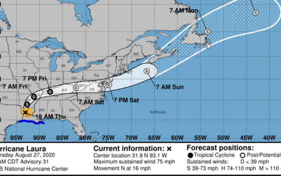
Flooding rainfall and strong winds continued to pound Louisiana as Tropical Storm Laura moved north, according to the latest advisory from the National Hurricane Center.
By noon Thursday, Laura had weakened into a strong tropical storm, less than 24 hours after it made landfall as a powerful Category 4 hurricane with 150 mph winds.
Hurricane Laura made landfall near Cameron, Louisiana, at 1 a.m. Thursday.
As of 1 p.m., the center of Tropical Storm Laura was located 65 miles east-northeast of Shreveport, Louisiana.
Laura is moving toward the north at 15 mph.
More: See photos, videos of Hurricane Laura damage in Texas
More: As Hurricane Laura approaches landfall, here’s what to do if storm causes flooding
On the forecast track, the center of Laura is forecast to move over Arkansas tonight, the mid-Mississippi Valley on Friday, and the mid-Atlantic states on Saturday.
Maximum sustained winds continue to drop, and were at 65 mph, with higher gusts, at 1 p.m.
Continued weakening is forecast, and Laura is expected to weaken to a tropical depression this evening or overnight.
More: Watch live webcams of Texas beaches
Where is Hurricane Laura now?
- Location: 65 miles east-northeast of Shreveport, Louisiana
- Movement: North at 15 mph
- Maximum sustained winds: 65 mph
- Next update: 4 p.m.
Information gathered from the National Hurricane Center.
Hurricane Laura watches and warnings
A storm surge warning is in effect for:
- Sabine Pass Texas to Port Fourchon, Louisiana
Read or Share this story: https://www.caller.com/story/news/2020/08/27/hurricane-laura-landfall-track-path-nhc-updates-texas-louisiana/3439752001/