- Severe weather leads to fallen trees, car crashes and flooding around the Triangle
- New video shows vehicles being swept away in historic, deadly flash floods in SA on June 12
- $40 million to go to underserved SC counties for Hurricane Helene recovery. Here's what you need to know.
- Family honors Air Force veteran Derwin Anderson Jr. after he died in June flash floods
- City of Wilmington addresses flooding on New Centre Drive
Slow-moving Hurricane Sally could bring 'historic life-threatening' flooding along Mississippi, Alabama, Florida coasts

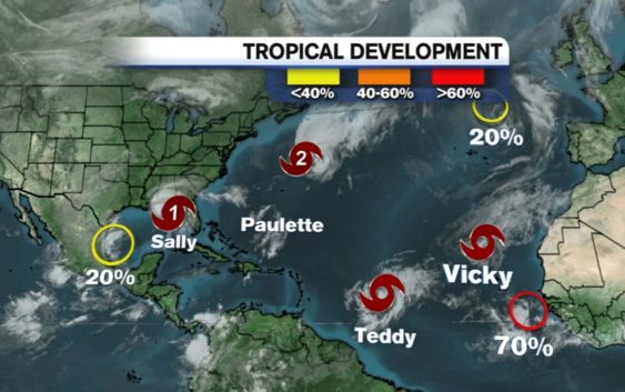
The National Hurricane Center now sees four named storms and seven active systems in the Atlantic storm basin.
Tropical Storm Sally remains a hurricane headed for the Gulf Coast, though it was downgraded to a Category 1 storm at 2 a.m. Tuesday. As of 10 p.m., Sally’s winds are up to 85 mph with 115 mph gusts.
Sally is 70 miles south of Mobile, Alabama.
The strength of the storm isn’t the main concern. Sally is only moving at 2 miles per hour. That slow movement, means it is going to drop an incredible amount of rain for an extended period of time.
Couple that with any significant wind speed, and you have a recipe for major damage.
The National Hurricane Center warns Sally could bring “historic life-threatening flash flooding through Wednesday.”
Sally is projected to make landfall sometime Tuesday night into Wednesday morning. It will be somewhere around Biloxi, Mississippi, Mobile, Alabama and Pensacola, Florida.
Sally is expected to bring extremely dangerous and life-threatening storm surge. Storm surge warnings have been issued from Port Fourchon in Louisiana to the Mississippi/Alabama border.
Hurricane conditions are expected early Tuesday in southeastern Louisiana and later that night along Mississippi, Alabama and Florida Panhandle.
Sally is the earliest “S” storm in recorded history.
Sally is just one of four named storms under observation right now. Paulette, Teddy, and Vicky are the others.
Tropical Storm Teddy is expected to become a hurricane Tuesday. It is also projected to strengthen into a Category 3 storm. The good news is, Teddy is expected to stay out to sea.
Tropical Storm Vicky formed Monday west of the Cabo Verde Islands. It is not expected to cause a serious impact and will be short-lived.
Preparing your hurricane kit during COVID-19
Out in the Atlantic, Hurricane Paulette is moving northeast at 28 mph with maximum sustained winds of 100 mph.
The eye of Paulette moved over Bermuda on Monday morning.
After hitting Bermuda, the storm is expected to turn north and stay away from the United States. Swells from Paulette are expected to impact parts of the Leeward Islands, the Greater Antilles, the Bahamas, Bermuda and the southeastern United States.
A tropical wave off Africa’s west coast has a 50 percent chance of development over the next 5 days. Another wave in the Gulf has a 10 percent chance of development in the same time period.
The next storm to become a tropical storm will be named Wilfred, the final name before moving on to the Greek alphabet. Here’s what happens if we run out of names.
The last time that happened was 2005–which is the current record holder for the most active hurricane season ever.
Copyright © 2020 WTVD-TV. All Rights Reserved.