- Man charged with sparking the most destructive wildfire in Los Angeles history
- Carolina Hurricanes start 2025-26 season hosting New Jersey Devils
- Speedy Sparks, bassist for Texas Tornados, other San Antonio music icons, has died
- Authorities make an arrest related to deadly January wildfire that leveled LA neighborhood
- AI simulation gives Carolina Hurricanes 20% chance to win 2026 Stanley Cup
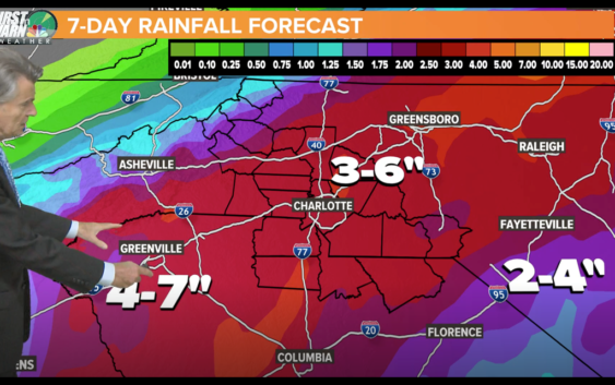
FLASH FLOOD WATCH: Tropical Depression Sally to bring heavy rain threat to the Carolinas
A Flash Flood Watch means there is the chance for rapid onset of flooding in the area. It’s a dangerous situation and can even affect areas that don’t normally flood
CHARLOTTE, N.C. — The remnants of Tropical Depression Sally are expected to enter the Carolinas on Thursday, bringing heavy rain and a flash flood threat to the area.
According to Chief Meteorologist Brad Panovich, Sally will interact with a frontal boundary and produce widespread heavy rain across the entire region.
“Rainfall totals of five to seven inches are expected,” Panovich said. “There could be a few isolated severe storms that produce south and east of I-85.”
Panovich said all residents should stay weather aware as the heavy rain can produce areas of flash flooding along small streams, creeks, and all flood-prone areas.
He also said some minor river flooding is possible, which could include the South Fork of the Catawba River. Flooding of parks, greenways, farmland, and secondary roads is possible.
A Flash Flood Watch means there is the chance for rapid onset of flooding in the area. It’s a dangerous situation and can even affect areas that don’t normally flood.
SEVERE WEATHER LIVE BLOG
8:39 a.m. – Matthew Police Department is asking residents to avoid the area of Hwy. 51 at Courtney Ln. due to a downed tree that is blocking the north and southbound travel lanes. Alternate routes are I-485 or Trade St.