- WATCH: Video Shows Confirmed Tornado touches down in Columbus County
- Residents begin clean up after storms, apparent tornado roll through NC Tuesday
- Flooding lingers in Liberty County neighborhoods near Trinity River with more rainfall expected
- North Carolina behind on hurricane preparedness, study shows
- North Carolina way behind on hurricane preparedness, study shows
FLASH FLOOD WATCH: Tropical Storm Sally to bring heavy rain threat to the Carolinas
A Flash Flood Watch means there is the chance for rapid onset of flooding in the area. It’s a dangerous situation and can even affect areas that don’t normally flood
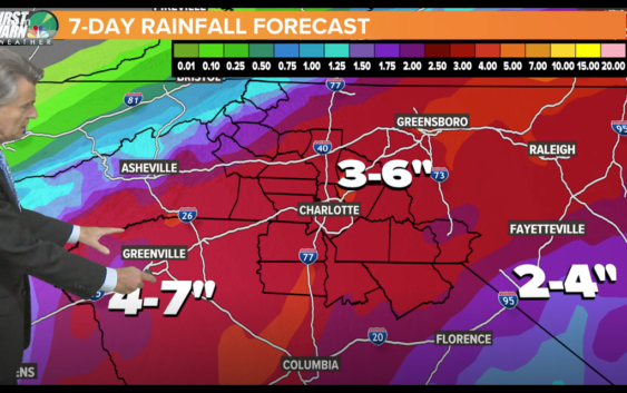
CHARLOTTE, N.C. — The remnants of Tropical Storm Sally are expected to enter the Carolinas on Thursday, bringing heavy rain and a flash flood threat to the area.
According to Chief Meteorologist Brad Panovich, Sally will interact with a frontal boundary and produce widespread heavy rain across the entire region.
“Rainfall totals of five to seven inches are expected,” Panovich said. “There could be a few isolated severe storms that produce south and east of I-85.”
Panovich said all residents should stay weather aware as the heavy rain can produce areas of flash flooding along small streams, creeks, and all flood-prone areas.
He also said some minor river flooding is possible, which could include the South Fork of the Catawba River. Flooding of parks, greenways, farmland, and secondary roads is possible.
A Flash Flood Watch means there is the chance for rapid onset of flooding in the area. It’s a dangerous situation and can even affect areas that don’t normally flood.