- EF-1 tornadoes ripped through Cypress, Waller County areas with winds at more than 100 mph, NWS reports
- Houston-area storm damage updates: Clean up continues after NWS says two EF-1 tornadoes and powerful derecho ripped through SE Texas
- Low risk of damaging winds, hail from Saturday storms
- EF 1 tornadoes ripped through Cypress, Waller County areas at more than 100 mph, NWS reports
- Caddo Mounds State Historic Site to celebrate new visitor center, traditional grass house after 2019 tornado
Tropical storm or depression expected to form in Gulf of Mexico soon: Track it here
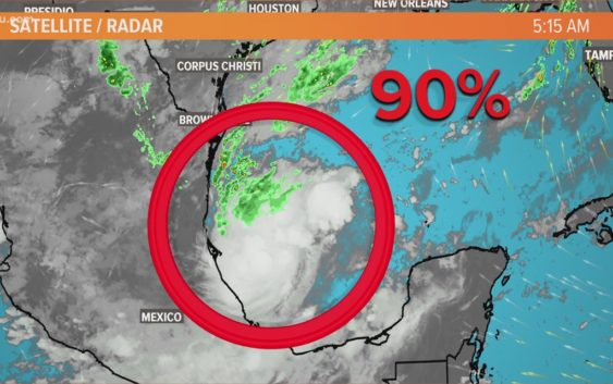
Invest 90L now has a 90% chance of development over the next two days.
HOUSTON — We could be looking at what could soon become Tropical Storm Wilfred in the Gulf of Mexico, according to KHOU 11 Meteorologist Blake Mathews.
Invest 90L right now is not a threat to the Houston area, but you can see the spaghetti models are not yet in agreement. Some have it looping back to Mexico or South Texas while others are heading to areas east of Texas.
The Houston area and Southeast Texas are expected to get a “cool front” on Friday that should help steer away any tropical development. (About that cool front: it will still be warm this weekend, but Houston’s weather will feel much nicer thanks to lower humidity. View Houston’s forecast here.)
As of Thursday morning, Invest 90L had a 90% chance of further development over the next 48 hours.
7 a.m. update from the National Hurricane Center:
“The National Hurricane Center is issuing advisories on Hurricane Teddy, located over the central tropical Atlantic and on Tropical Storm Vicky, located over the eastern tropical Atlantic. The National Hurricane Center has issued its last advisory on Tropical Depression Sally, located inland over eastern Alabama.
Thunderstorm activity has continued to increase and become better organized this morning in association with a well-defined low pressure system located over the southwestern Gulf of Mexico. Upper-level winds are gradually becoming more conducive for development and, if this recent development trend continues, a tropical depression or a tropical storm could form later today. The low is expected to meander over the southwestern Gulf of Mexico for the next day or so before moving slowly northward to northeastward on Friday and Saturday. An Air Force Reserve reconnaissance aircraft is scheduled to investigate the disturbance this afternoon. * Formation chance through 48 hours…high…90 percent. * Formation chance through 5 days…high…90 percent.”
Everyone along the Gulf Coast will want to watch Invest 90L closely. It brings the possibility of heavy rain somewhere along the Gulf Coast by the middle of next week.
Mathews says models have done an extremely poor job with forecasting tropical systems this year with many storms ending up outside the cone of uncertainty, including on-going Sally which ended up *well east* the cone, hitting Pensacola instead of New Orleans. Therefore the prudent thing to do is just watch along with us and check back in at least once a day to get a progress update on this developing Invest.
If any other storms develop, which is extremely likely, we would then have to use the Greek alphabet for only the second time in recorded history; the first time being 2005.
A lot of tropical development in the Atlantic right now
There is plenty to track and name out there right now, but the system in the Gulf is the only one we have any concerns about in Texas right now.
The National Hurricane Center is issuing advisories on Tropical Depression Sally, located inland over southeastern Alabama, on Hurricane Teddy, located over the central tropical Atlantic, and on Tropical Storm Vicky, located over the eastern tropical Atlantic:
Be prepared if tropical weather does come our way
BEFORE THE STORM
- Make a home inventory
- Have a current copy of your declarations page that has your policy number and your agent’s number
- Review your policy with your insurance agent to determine if you have adequate coverage
- Repair loose boards, shingles, shutters and downspouts to prevent them from becoming an issue in high winds or torrential rain
- Have an evacuation plan, and include plans for your pets
- Make sure your emergency equipment is in working order, including a battery-powered radio, flashlights and extra batteries. Also, make sure to gather all medicine, replenish your first-aid kit and stock a week’s worth of non-perishable food and water
- Charge your cell phone and fill your car with gas
- Program all emergency phone numbers
DURING THE STORM
- If you are advised to evacuate, leave as soon as possible. Retain all related receipts – they may be considered in your claim. If you aren’t in a recommended evacuation and you plant to stay home, stay informed by listening to weather alerts
- Keep windows and doors closed at all time, and, if possible, board them up with wooden or metal shutters
- Stay away from the windows and in the center of the room, or, stay in an interior room
- Avoid flood water, as it may be electrically charged from downed power lines
- Check on family members and friends
AFTER THE STORM
- Check to be sure your family members are safe
- If you did evacuate, wait for official notice that it is safe to re-enter your neighborhood and your house
- Document damaged property, and take photos and videos. Don’t dispose of any damaged items without approval
- Keep a record of any temporary repairs or expenses to prevent further damage to your property