- Here's how to get your flooding debris picked up by the City of Houston
- Mosquito activity on the rise due to rainfall, flooding across Texas
- Volunteers help Conroe community clean up in wake of flooding in Montgomery County
- Why leaders are urging NC residents to start hurricane prep now
- Storms could produce hail, damaging winds south of Charlotte
Hurricane, tropical storm and storm surge watches in effect for Texas coast ahead of Tropical Storm Beta
Tropical Storm Beta has 60 mile-per-hour sustained winds as it moves through the Gulf of Mexico.
HOUSTON — Tropical Storm Beta continues moving through the Gulf of Mexico. It’s expected to strengthen into a hurricane, according to the National Hurricane Center.
The forecast track for the Gulf system remains uncertain.
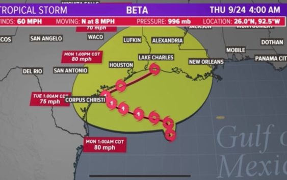
As of 4 a.m. Saturday, Tropical Storm Beta had 60 mph sustained winds with gusts at 70. It was moving to the north at 8 mph. It’s 300 miles southwest of the mouth of the Mississippi River.
Storm surge and hurricane watches have been issued along the Texas Gulf Coast.
Key messages from National Hurricane Center (4 a.m. Sat.)
- There is an increasing risk of heavy rainfall along the northwest Gulf Coast Sunday through at least the middle of next week as Beta is forecast to move slowly toward and along or offshore of the coast through that time.
- Life-threatening storm surge and hurricane-force winds are possible along portions of the Texas coast early next week with tropical storm conditions possible by late this weekend. Storm surge and hurricane watches are in effect and residents in these area should ensure they have their hurricane plan in place and follow advice given by local officials.
RELATED: Galveston County considers voluntary evacuation of Bolivar Peninsula ahead of Tropical Storm Beta
Tropical Storm Beta forecast cone
Tropical Storm Beta spaghetti models
Gulf Coast rainfall forecast (Euro model)
Current watches and warnings
Hurricane and storm surge watches have been issued from Port Mansfield to High Island. Significant coastal flooding may produce significant damage to beaches and dunes.
10 p.m. Friday update from the National Hurricane Center:
At 1000 PM CDT (0300 UTC), the center of Tropical Storm Beta was located near latitude 25.5 North, longitude 92.3 West. Beta is moving toward the north-northeast near 12 mph (19 km/h). A slow westward motion is expected to begin late Saturday, with a slow northwestward motion forecast to begin late Sunday and continue through late Monday. On the forecast track, the center of Beta will slowly approach the Texas coast into early next week.
Data from the Air Force Hurricane Hunter aircraft indicate that maximum sustained winds have increased to near 60 mph (95 km/h) with higher gusts. Additional strengthening is forecast, and Beta is expected to become a hurricane on Sunday.
Tropical-storm-force winds extend outward up to 175 miles (280 km) from the center.
The estimated minimum central pressure is 996 mb (29.42 inches).
HAZARDS AFFECTING LAND
STORM SURGE: The combination of a dangerous storm surge and the tide will cause normally dry areas near the coast to be flooded by rising waters moving inland from the shoreline. The water could reach the following heights above ground somewhere in the indicated areas if the peak surge occurs at the time of high tide…
Port Mansfield, TX to High Island, TX including Baffin Bay, Corpus Christi Bay, Copano Bay, Aransas Bay, San Antonio Bay, Matagorda Bay, and Galveston Bay…2-4 ft Mouth of the Rio Grande to Port Mansfield, TX…1-3 ft High Island, TX to Morgan City, LA including Sabine Lake, Calcasieu Lake, and Vermilion Bay…1-3 ft
The deepest water will occur along the immediate coast in areas of onshore winds, where the surge will be accompanied by large and destructive waves. Surge-related flooding depends on the relative timing of the surge and the tidal cycle, and can vary greatly over short distances. For information specific to your area, please see products issued by your local National Weather Service forecast office.
WIND: Hurricane conditions are possible within the hurricane watch area by late Monday or Monday night, with tropical storm conditions possible by late Sunday. Tropical storm conditions are possible within the tropical storm watch area along the upper Texas and southwestern Louisiana coast as early as late Saturday. Tropical storm conditions are possible within the tropical storm watch area along the south Texas coast late Sunday.
RAINFALL: There is an increasing risk of heavy rainfall and flooding along the northwest Gulf Coast Sunday through at least the middle of next week as Beta is forecast to move slowly toward and along or offshore of the coast through that time. For additional information, see products from your local National Weather Service office.
SURF: Swells are expected to increase and reach the coast of Texas and the Gulf Coast of Mexico over the weekend, generated by a combination of Beta and a cold front entering the northern Gulf of Mexico. These swells are likely to cause life-threatening surf and rip current conditions. Please consult products from your local weather office.
Be prepared if tropical weather does come our way
BEFORE THE STORM
- Make a home inventory
- Have a current copy of your declarations page that has your policy number and your agent’s number
- Review your policy with your insurance agent to determine if you have adequate coverage
- Repair loose boards, shingles, shutters and downspouts to prevent them from becoming an issue in high winds or torrential rain
- Have an evacuation plan, and include plans for your pets
- Make sure your emergency equipment is in working order, including a battery-powered radio, flashlights and extra batteries. Also, make sure to gather all medicine, replenish your first-aid kit and stock a week’s worth of non-perishable food and water
- Charge your cell phone and fill your car with gas
- Program all emergency phone numbers
DURING THE STORM
- If you are advised to evacuate, leave as soon as possible. Retain all related receipts – they may be considered in your claim. If you aren’t in a recommended evacuation and you plant to stay home, stay informed by listening to weather alerts
- Keep windows and doors closed at all time, and, if possible, board them up with wooden or metal shutters
- Stay away from the windows and in the center of the room, or, stay in an interior room
- Avoid flood water, as it may be electrically charged from downed power lines
- Check on family members and friends
AFTER THE STORM
- Check to be sure your family members are safe
- If you did evacuate, wait for official notice that it is safe to re-enter your neighborhood and your house
- Document damaged property, and take photos and videos. Don’t dispose of any damaged items without approval
- Keep a record of any temporary repairs or expenses to prevent further damage to your property