- California wildfire burns out of control but firefighters could get a break when winds diminish
- 'Flooding is our number one natural disaster' | Breaking down the voter-approved Harris County Flood Control District tax rate hike
- Powerful Category 3 Hurricane Rafael knocks out power in Cuba as it heads to the island
- NC Forest Service warns of increased wildfire risk in western part of state after Helene
- First responders searched for hours after being told two people were swept away in flash flood
TROPICAL STORM: Tracking Beta as it approaches Texas Coast

Outer rain bands could impact portions of South-Central Texas Sunday evening.
SAN ANTONIO — Tropical Depression 22 has formed into Tropical Storm Beta in the Gulf of Mexico. This system is expected to impact the Texas coast.
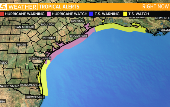
Tropical Storm and Hurricane Watches are in effect along the Texas Coast.
A Tropical Storm Warning and a Hurricane Watch are in effect north of Port Aransas.
A Storm Surge Watch is in effect along the Middle Texas Coast.
Sustained winds of 60 mph have been recorded, and the storm could strengthen to a Category 1 hurricane by Sunday.
Beta was the third system to get a name in seven hours on Friday, the first time three storms have ever been named in a day.
Wilfred formed in the Atlantic earlier in the morning, which means we have officially run out of the ‘regular’ 2020 Atlantic season hurricane names, and we will now continue on to the Greek alphabet. A short time later, Subtropical Storm Alpha formed near the coast of Portugal.
Beta is expected to move westward through the Gulf of Mexico, turning toward the Middle Texas Coast later today.
In South Central Texas, we can expect the most significant impact to be heavy rain and possible flooding.
Outer rain bands could impact portions of South-Central Texas Sunday evening with better chances for showers and thunderstorms Monday and Tuesday.
Get the last weather news straight to your phone. You can download it in the App Store or Google Play. Also be sure to follow KENS 5 on Facebook, YouTube, Twitter and Instagram for updates on the weather.
Follow the KENS 5 Weather Team