- Services planned for Conroe police officer who died after tornado ripped through his home
- Flooding sweeps away 200 ostriches from Central Texas ranch, search efforts underway
- Weather IQ: Understanding the difference between EF0 to EF5 tornadoes
- What is storm surge? Rising water and flooding the most deadly parts of a hurricane
- Turn around, don't drown: Water on roads a killer during hurricane season
Slow-moving tropical storm Beta expected to flood Texas, Louisiana coast
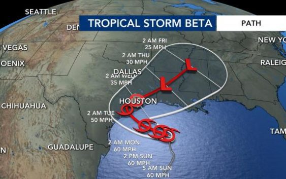
Tropical Storm Beta is in the Gulf of Mexico and inching toward Texas and Louisiana. The storm is moving at about 3 mph, which is nearly stationary.
Beta is expected to bring intense rainfall for extended periods of time and flood the coast because of how slow the storm is moving.
Rain from the storm has already began flooding the coast of Texas.
Outer bands of the storm will continue to impact the Gulf States on Saturday and the Florida panhandle.
This storm make landfall in Texas by Monday night or Tuesday morning somewhere between Houston Texas and Corpus Christi. About 8 to12 inches of rain is expected to come to those areas of Texas before the storm moves northeast.
Some areas of Texas could see 20 inches of rain.
Rainfall is expected to spread northward into the lower Mississippi River Valley by mid-week where flash, urban and river flooding is possible, according to the latest update from the National Hurricane Center.
Life-threatening storms surges are a danger on the coast of Texas and Louisiana.
In North Carolina, we could see remanent moisture from the storm and increased rain chances. We will likely feel this on Friday.
Hurricane Teddy, a Cat. 2 storm, is forecast to move east of Bermuda late Sunday or Monday, according to the NHC. Conditions likely won’t improve on the island until Monday evening, however.
Teddy is expected to gain strength as it moves over ports of the Atlantic Canada. The storm will transition to a post-tropical cyclone, which means it is no longer a tropical cyclone but still has heavy rain and high winds.
Hurricane Teddy is not expected to impact North Carolina, but is expected to impact portions of Atlantic Canada early this week.

The coast of North Carolina is expected to have life-threatening rip currents over the next couple of days because of Teddy. If you are headed to the beach, make sure to swim near a life guard. If you do get caught in a rip current, don’t panic and swim parallel to the shore.
As we head into Thursday we expect this threat to die down.

Tropical Storm Wilfred is forecast to die down in the next couple days. Right now, the storm is more than 1,200 miles away from the Lesser Antilles.
For only the second time in recorded history, all of the possible hurricane names have been used up this season, and we still have 10 weeks to go. We will now switch into using the Greek alphabet for names.