- Whiteville resident recalls events from Tuesday nights tornado
- Tornado damage reported in southern NC after Tuesday's severe storms
- If your home floods, here are steps you can take to address mold
- WATCH: Video Shows Confirmed Tornado touches down in Columbus County
- Residents begin clean up after storms, apparent tornado roll through NC Tuesday
Beta downgraded to a tropical depression, Flash Flood Watch continues for parts of Houston area
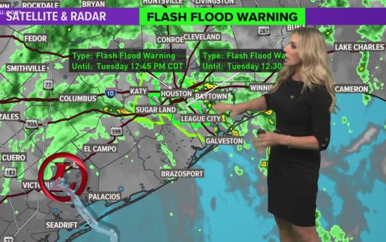
Ongoing high water spots are expected throughout the day Tuesday after Beta made landfall on the Texas coast last night.
HOUSTON — Tropical Storm Beta made landfall Monday night near the southern end of the Matagorda Bay Peninsula with sustained winds of 45 mph.
As of 12 p.m. Tuesday, Beta was a tropical depression, but despite no longer being a tropical storm the flood threat remains for Southeast Texas for at least the next 24 hours. Beta was nearly stationary (now moving northeast at only 2 mph) with winds at 35 mph. It is now expected to head east-northeast through Matagorda, Brazoria and Harris Counties – continuing the chance for flooding through tonight into Wednesday morning.
HIGH WATER LIST: Flooding reported on Houston-area roads
PHOTOS & VIDEO: Street flooding in Houston and Galveston areas
MONITORING THE BAYOUS: Here are the spots we are watching closely
Street flooding will continue to be the greatest threat Tuesday and early Wednesday in the Houston area. In some areas, especially southeast of Houston, we have received more than 12 inches of rain in less than 24 hours. Flooding inland shifted from our coastal areas last night and is a continued threat through Harris County today.
WEATHER ALERTS:
Rain will continue to sweep in across the Houston Galveston area all day Tuesday and for a portion of Wednesday. A Flash Food Watch is in effect for the entire area.
Where is Tropical Depression Beta going?
After moving northeast through Matagorda and Brazoria Counties, Beta will head through Houston and areas east by Tuesday evening. By early Wednesday afternoon, Beta will be out of the Houston area and over Beaumont and entering Louisiana.
What can Houston and Southeast Texas expect?
Periods of fast moving, heavy rain are expected to continue Tuesday, even though Beta is no longer a tropical storm. Flooding in low-lying areas is the greatest threat with this system so far.
At this time we are not expecting widespread structural flooding issues across our inland communities, but we are watching our bayous closely. It is best to stay home Tuesday if you can as many cars have been flooded already.
MONITORING THE BAYOUS: Here are the spots we are watching closely
Our primary concern with this system will be isolated spots of street flooding during those heavy downpours and flooding/storm surge in our coastal communities.
Interactive tropical tracker map
Additional rainfall amounts expected Tuesday and Wednesday
National Hurricane Center Tuesday morning update
1. Significant flash and urban flooding is occurring and will continue for the middle and upper Texas coast today. The slow motion of Beta will continue to produce a long duration rainfall event from the middle Texas coast to southern Louisiana. Flash, urban, and minor to isolated moderate river flooding is likely. Periods of rainfall will spread east into the Lower Mississippi Valley and portions of the Southeast through the end of the week. Flash, urban, and isolated minor river flooding is possible on smaller rivers.
2. Persistent onshore flow will continue to result in above normal high tides, and coastal flooding over the next few days will be slow to recede. For information on the ongoing coastal flooding, please refer to coastal flood products issued by local National Weather Service offices.