- Southport hosts annual Hurricane Expo ahead of the 2024 season
- How to protect your car before a hailstorm
- ‘We lost everything’: East Texas residents confront their future after flooding
- Here's how to get your flooding debris picked up by the City of Houston
- Mosquito activity on the rise due to rainfall, flooding across Texas
Hurricane Warning in effect for Louisiana, Mississippi as Zeta eyes Gulf Coast
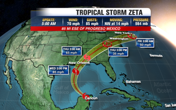
RALEIGH, N.C. — Zeta weakened back into a tropical storm overnight as it moved over the Yucatán Peninsula, but the system is expected to restrengthen before hitting the U.S.
According to the National Hurricane Center, Zeta has maximum sustained winds of 65 miles per hour, and it is moving northwest at 14 miles per hour. As of 11 a.m. EST, it’s 25 miles north-northeast of Progreso, Mexico.
Working over land has weakened Zeta, but it is expected to strengthen back to Hurricane level as it heads toward open water. Hurricane Warnings were issued for the coastlines in Louisiana and Mississippi.
Parts of the peninsula are under a hurricane warning. Zeta will head into the Gulf of Mexico and start tracking toward Louisiana, where it is expected to make landfall sometime Wednesday afternoon. The area could feel tropical storm-force winds by as early as Wednesday morning.
Louisiana has felt the brunt of the record-setting 2020 hurricane season. So far, four named storms–Cristobal, Delta, Laura, and Marco–have made landfall in the state.
Louisiana Gov. John Bel Edwards urged his state’s citizens to monitor the storm, and the state activated its Crisis Action Team.
Storm Ready 2020: Preparing in a Pandemic
Zeta broke the record for the earliest storm of its name, which was set on Nov. 29, 2005.
This year’s season has so many storms that the hurricane center has turned to the Greek alphabet after running out of official names. Zeta is the furthest into the Greek alphabet the Atlantic season has gone.
Copyright © 2020 WTVD-TV. All Rights Reserved.