- EF-1 tornadoes ripped through Cypress, Waller County areas with winds at more than 100 mph, NWS reports
- Houston-area storm damage updates: Clean up continues after NWS says two EF-1 tornadoes and powerful derecho ripped through SE Texas
- Low risk of damaging winds, hail from Saturday storms
- EF 1 tornadoes ripped through Cypress, Waller County areas at more than 100 mph, NWS reports
- Caddo Mounds State Historic Site to celebrate new visitor center, traditional grass house after 2019 tornado
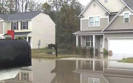
The latest: Entire viewing area now under flash flood warning, 2-3 more inches of rain likely
Heavy rain and flooding conditions are expected to worsen Thursday across central North Carolina, according to WRAL meteorologist Elizabeth Gardner. “Our situation will get more and more dangerous as we go throughout the day,” she said.
What to know:
- The entire viewing area, including the Triangle, is under a flash flood warning until 2:15 p.m. View all alerts.
- Sudden downpours and dangerous flash flooding are possible throughout the afternoon. Conditions should improve around 5 p.m.
- Flooding is most severe east of Raleigh, where more than 7 inches have fallen in the Rocky Mount area, and up to 12 inches are possible.
Helpful links: View all active weather alerts | Track the rain with the DualDoppler5000 | Get a live look at Triangle weather conditions
The latest:
11:00 a.m.: Nia Harden is in the Storm Tracker checking out road conditions across the Triangle, where most roads are seeing some ponding. WRAL Elizabeth Gardner said our southern counties have now been added to the flash flood warning as a band of heavy rain approaches those areas.
10:45 a.m.: Even in Fayetteville, which escaped much of the flooding, a neighborhood is flooded on Bombay Drive where a creek overflowed. The City of Fayetteville has placed road barricades on Bombay Drive, Ray Avenue at Cross Creek, Orange Street, Devonshire Drive, NC-53 and Englewood Drive, near the Ann Street Bridge and on L A Dunham Road due to rising waters. Cumberland County is now under a flash flood warning until 4:30 p.m.
10:30 a.m.: When will the rain start to taper off today? WRAL Zach Maloch said our western counties, including Orange, Durham and Person, should see the rain coming to an end by 4 p.m. In Raleigh and Cary, it will taper off closer to 5 p.m.
The bulk of the rain should be out of the area completely overnight, with just a stray shower possible early Friday. A total of 1-3 more inches of rain could fall over the next 3-4 hours, Maloch said.
Meteorologists are closely watching the Neuse River, which could be at moderate flood stage in Goldsboro by Friday. The Neuse could be at moderate flood stage in Smithfield and Clayton by Thursday night.
10:15 a.m.: On Fountain Drive in southeast Raleigh, Walnut Creek overflowed its banks, flooding the bottoms of several cars parked in the community. The road has been blocked off to traffic.
A homeowner who lives at the bottom of a hill in the community told WRAL Amanda Lamb water entered her home but it is starting to recede. She said this happens often in heavy rain events and she has gotten used to it.

New crashes have been reported on major Raleigh routes, including on I-40 East at Rock Quarry Road and on I-440 E near Hillsborough Street and Wade Avenue. Flash flooding was also reported on Lake Boone Trail near I-440.
While school days have not changed in the Triangle, Wake County Public Schools announced food distribution to students learning remotely has been canceled Thursday due to inclement weather.
10 a.m.: Conditions are also poor in western North Carolina, where water rescues are underway. The Conover Fire Department tweeted a group of 15 to 20 campers were trapped at the Hiddenite Family Campground.
According to WCNC Charlotte, Duke Energy estimated nearly 2,500 people were without power in Catawba County due to the storms. The station reports 143 people were evacuated from Corvian Community Elementary School in Charlotte because of floodwaters.
In Charlotte, I-85 looked more like a river at one point Thursday morning. A record was broken near uptown Charlotte, where Little Sugar Creek recorded a record crest of 15.2 feet, the highest it’s been since 1997.
Storms and heavy rain will continue to move eastward, and Gardner said “the situation will only get worse” Thursday. Anywhere from 1-2 inches of rain could fall per hour.
Conditions continue to be worst east of Raleigh, where U.S. Highway 301 in Rocky Mount and Old Route 22 in Kenly are flooded.
9:45 a.m.: More than 7 inches of rain have already fallen in the Rocky Mount, and at least 3 inches fell in the Triangle. On Thursday, isolated heavy downpours will continue to drop another 2 to 5 inches across the state.
9 a.m.: A flash flood warning is in effect for the Triangle and Sandhills, including Wake County, until 2:15 p.m. Flash flooding can occur unexpectedly from heavy downpours, flooding roads and making for dangerous driving conditions.
8:30 a.m.: While rain is expected to be heaviest northeast of Raleigh, the Triangle is also at risk for flash flooding and road closures all day Thursday. “We’re especially worried about folks around the Interstate 95 corridor,” Gardner said. “We could see flooding anywhere but that’s going to be where it’s most likely.”
Rain-related crashes and road closures
In the Triangle, weather-related crashes slowed traffic on U.S. Interstate 1 near Ten Ten Road in Apex and on Interstate 440 near Glenwood Avenue Thursday morning. East of the Triangle, cars were getting stuck in floodwaters, and major routes like U.S. Highway 301 were blocked in spots.

Gardner said the rain will be heaviest Thursday morning, throughout lunchtime and for most of the afternoon, with conditions improving by 5 p.m.
There was a small lull in the rain Thursday morning, but Gardner said another large band of rain is expected to be problematic through the late morning and early afternoon.
There’s also a risk for severe weather Thursday afternoon, when gusty winds and isolated tornadoes are possible.

![]()
Crashes are likely to be numerous throughout the Triangle for the Thursday commute as drivers navigate wet roads.
![]()
Pay attention to flooded streets and closed roads and do not try to drive around barricades.
“Do not drive your car into floodwaters,” Gardner said. “Avoid them at all costs.”
Cooler, drier weather ahead
Cooler temperatures and drier conditions are ahead for Friday and the weekend.

![]()
There could be a few showers left over Friday morning, but the day will be dry overall. Fall weather will return Saturday and Sunday, which will be sunny and much cooler, with highs in the mid to upper 60s.