- Flood Watch issued for San Antonio and surrounding areas
- 9-year-old’s heroic act saves parents after Oklahoma tornado: ‘Please don’t die, I will be back’
- Hurricanes beat Islanders to clinch NHL playoff 1st-round series in 5 games
- Drury, Noesen help Hurricanes beat Islanders 6-3 to clinch NHL playoff 1st-round series in 5 games
- Weekend storm damage caused by 2 confirmed tornadoes in Central Texas
The latest: Flash flood warning in effect for Triangle, Sandhills, 2 to 5 more inches of rain likely
Heavy rain and flooding conditions are expected to worsen Thursday across central North Carolina, according to WRAL meteorologist Elizabeth Gardner.”Our situation will get more and more dangerous as we go throughout the day,” she said.
What to know:
- Most of the viewing area, including the Triangle, is under a flash flood warning until 2:15 p.m.
- Sudden downpours and dangerous flash flooding are possible throughout the afternoon. Conditions should improve around 5 p.m.
- Flooding is most severe east of Raleigh, where more than 7 inches have fallen in the Rocky Mount area, and up to 12 inches are possible by Friday morning.
Helpful links: View all active weather alerts | Track the rain with the DualDoppler5000 | Get a live look at Triangle weather conditions
The latest:
10 a.m.: Conditions are also poor in western North Carolina, where water rescues are underway. The Conover Fire Department tweeted a group of 15 to 20 campers were trapped at the Hiddenite Family Campground.
According to WCNC Charlotte, Duke Energy estimated nearly 2,500 people were without power in Catawba County due to the storms.
Storms and heavy rain will continue to move eastward, and Gardner said “the situation will only get worse” Thursday. Anywhere from 1-2 inches of rain could fall per hour.
9:45 a.m.: More than 7 inches of rain have already fallen in the Rocky Mount, and at least 3 inches fell in the Triangle. On Thursday, isolated heavy downpours will continue to drop another 2 to 5 inches across the state.
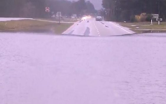
9 a.m.: A flash flood warning is in effect for the Triangle and Sandhills, including Wake County, until 2:15 p.m. Flash flooding can occur unexpectedly from heavy downpours, flooding roads and making for dangerous driving conditions.
8:30 a.m.: While rain is expected to be heaviest northeast of Raleigh, the Triangle is also at risk for flash flooding and road closures all day Thursday. “We’re especially worried about folks around the Interstate 95 corridor,” Gardner said. “We could see flooding anywhere but that’s going to be where it’s most likely.”
Rain-related crashes and road closures
In the Triangle, weather-related crashes slowed traffic on U.S. Interstate 1 near Ten Ten Road in Apex and on Interstate 440 near Glenwood Avenue Thursday morning. East of the Triangle, cars were getting stuck in floodwaters, and major routes like U.S. Highway 301 were blocked in spots.
Gardner said the rain will be heaviest Thursday morning, throughout lunchtime and for most of the afternoon, with conditions improving by 5 p.m.
There was a small lull in the rain Thursday morning, but Gardner said another large band of rain is expected to be problematic through the late morning and early afternoon.
There’s also a risk for severe weather Thursday afternoon, when gusty winds and isolated tornadoes are possible.

![]()
Crashes are likely to be numerous throughout the Triangle for the Thursday commute as drivers navigate wet roads.
![]()
Pay attention to flooded streets and closed roads and do not try to drive around barricades.
“Do not drive your car into floodwaters,” Gardner said. “Avoid them at all costs.”
Cooler, drier weather ahead
Cooler temperatures and drier conditions are ahead for Friday and the weekend.

![]()
There could be a few showers left over Friday morning, but the day will be dry overall. Fall weather will return Saturday and Sunday, which will be sunny and much cooler, with highs in the mid to upper 60s.