- State of Texas wants you to report damage from flooding | In English and Spanish
- Texas flooding: Weather conditions in Houston-area communities with high water
- Texas flooding: Weather conditions in Houston-area communities with high water; resources for flood victims
- Have you been affected by the floods? Here's what Harris Co. wants you to do with debris
- Texas flooding: Resources for flood victims, plus conditions in Houston-area communities with high water
Potential for rain, severe weather overnight Sunday
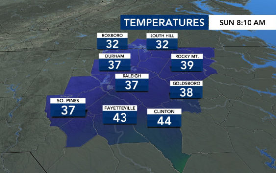
Central North Carolina is in for one more warm day before the weather changes – first to rain and the chance for storms, then to wintry cold to start the work week.
Sunday will dawn under cloudy skies, and those clouds will build in as the day goes on, WRAL meteorologist Mike Maze said.
“We should not see rain move into the area until very early in the evening. Rain is likely overnight,” Maze said.
A storm system will move into the Carolinas from the Gulf Coast, bringing rain and a minimal chance for some severe weather early Monday and into Monday morning, Maze said.
“The primary threat comes from a damaging wind gust with a small possibility for a tornado,” he said. “The air mass does not look ‘unstable’ enough for this to be a widespread severe risk nor a strong severe risk, but there’s enough shear in the atmosphere, meaning a strong jet stream aloft, that any winds from aloft could make their way to the ground and create damage.”
Behind the system, colder air moves in and brings the chance for some snow in the North Carolina mountains.
Raleigh and the surrounding area could see about an inch of rain total before noon on Monday.
After the storms pass, Monday stays windy but warm, with a high forecast in the mid- to upper 60s.
The real chill comes Monday night and Tuesday.
Tuesday will be sunny, but it will feel like winter, with the high temperature only in the 40s.
Tuesday, Wednesday and Thursday will all be chilly days in the Triangle, and overnight temperatures will drop into the upper 20s to low 30s.
