- If your home floods, here are steps you can take to address mold
- WATCH: Video Shows Confirmed Tornado touches down in Columbus County
- Residents begin clean up after storms, apparent tornado roll through NC Tuesday
- NC State researchers find increased fecal contamination in coastal waters due to sunny day flooding
- Flooding lingers in Liberty County neighborhoods near Trinity River with more rainfall expected
Level 4 severe weather risk dropped from NC; damaging winds still biggest threat to Triangle
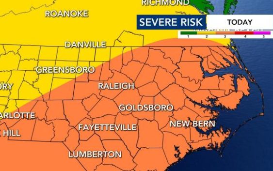
Although the threat for dangerous weather Thursday afternoon remains very high, North Carolina is no longer in the Level 4 risk zone for severe weather.
Tornadoes, damaging winds and hail are all possible in central North Carolina, including the Triangle, on Thursday. The National Weather Service Storm Prediction Center (NWS SPC) has the WRAL viewing area under a Level 3 risk for severe weather.
Thursday afternoon, the NWS SPC removed the southeast corridor of the state from a Level 4 risk. That’s a significant change from Wednesday, when all of central and eastern North Carolina were placed under a Level 4 risk.
Downed trees, and isolated power outages are possible. Tornadoes are more likely to occur in our southern and eastern counties.
“We’re still under a level 3 risk, which is serious,” WRAL Meteorologist Elizabeth Gardner said. “Our risk for tornadoes is a little bit lower.”
The key in what we will see depends on the placement of the emerging warm front. Gardner said that front could move through around lunchtime and deliver a warm air mass that could bump our temperatures into the low 70s.
“Right now, we’re still in a cool, stable air mass,” Gardner said. “We have to transport this air mass into North Carolina before we’re going to have the right setup for severe storms. That still looks possible, but we’re going to be watching it and tracking it throughout the day today.”
The warm front is lifting north into North Carolina and dew points and temperatures area climbing to the south.
“This front is moving a lot more slowly than advertised by the models [Wednesday],” Gardner said. “If this front can’t push all the way into our viewing area, then we won’t see as much severe weather as folks saw down south.”
The timeframe for the storms has shifted back a bit, as the line of storms now appears as if they won’t move into our area until around 6 p.m. Storm cells will generally move northeast, impacting the I-95 corridor through about 10 p.m.

The Storm Prediction Center is warning about the chance for egg-sized hail at least 2 inches in diameter, locally damaging winds up to 75 mph and several strong tornadoes, which could blow at more than 100 mph on Thursday.
Damaging winds pose the biggest threat.
“We’ve backed off to a medium risk for tornadoes today,” Gardner said. “Hail is possible, flooding with this system is unlikely.”
By noon, central North Carolina will see some sprinkles under mostly cloudy skies. We’ll mainly see patchy, light rain through midday. Noon temperatures ranged from 72 in Clinton to 54 in Roxboro. Clouds were starting to break up to the southeast, putting the pieces in place for a storm.
Storm warnings are possible over Durham and Southern Pines between 3 and 4 p.m. Wake County and Fayetteville will be in play through the normal time of the evening commute – through about 7 p.m.

Travel and outdoor activity during those hours could be dangerous. With the forecast in mind, Durham Public Schools announced that all students would learn remotely, so they can be at home during the hours of greatest risk.
Most of the Triad and points west in North Carolina are under a Level 2 risk.
Other schools followed with plans for remote learning or early dismissal on Thursday.
Wake County officials canceled all first- and second-dose coronavirus vaccinations scheduled for Thursday. The appointments have been rescheduled for Friday at the same times and locations. All scheduled Friday appointments also will be held.
The county also suspended free public testing on Thursday. Tests will resume on Friday. City crews in Raleigh were clearing blockages of inlets, grates and culverts to remove debris.
“This has the potential to do even more damage than we thought yesterday,” Gardner said.
Instead of one large system, WRAL meteorologist Zach Maloch said the storms will come in waves beginning Thursday afternoon, and each has the potential to produce life-threatening impacts like tornadoes.
Conditions could be worst during the evening commute.
“After 8 p.m. the tornado risk quickly diminishes,” Campbell said.
Level 4 risk is rare in North Carolina
The last time a Level 4 risk was issued a day before a storm system in North Carolina was in 2012.
In April 2019, the Storm Prediction Center issued a Level 4 risk alert for conditions on the same day, and the National Weather Service counted 57 tornado reports that day.
Gardner referenced North Carolina’s worst tornado outbreak to date, which occurred on April 16, 2011, when 30 tornadoes were confirmed across the state.
Last month, an EF2 tornado killed three people in Brunswick County near Wilmington.
“I’m not saying that’s what’s going to happen tomorrow, but it’s highly unusual to have a risk level this high,” Gardner said.
It will be especially important to keep devices charged beforehand, have an emergency plan in place for your household and download the WRAL Weather app to receive severe weather alerts.
If there is a tornado warning in the viewing area, WRAL meteorologists will be tracking the storm on air. You can watch on TV or right in the app. There were 23 tornado reports and 43 reports of hail in the southeast on Wednesday.

Thursday’s high will be warm, in the mid 70s. The day will begin with cloudy skies, a light breeze and a small chance for showers, then showers and storms will become more likely later in the afternoon and into the evening.
There is a 30 percent chance for rain on Friday, and highs will stay around 60 degrees. The weekend looks mostly sunny and dry but colder, with highs in the mid to upper 50s for both Saturday and Sunday.
