- Rock Hill storm damage costs are 'somewhere around $5 million.' That number doesn't include damage to personal property
- Rock Hill storm damage costs are 'somewhere around $5 million.' That number doesn't include damage to personal property
- ‘Somewhere around $5 million’ | Rock Hill officials see major storm damage costs
- The deadliest tornadoes to ever hit Austin
- Whiteville resident recalls events from Tuesday nights tornado
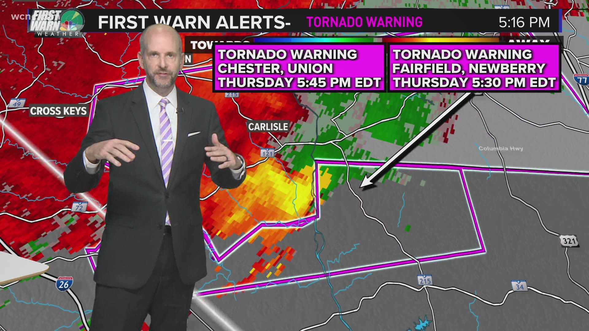
Tornado possible in Chester County and Lancaster counties in South Carolina
A line of severe thunderstorms is approaching Charlotte and moving eastward across the Carolinas.
CHARLOTTE, N.C. — A tornado is possible in Chester, Lancaster, and Kershaw counties in South Carolina as a severe thunderstorm capable of producing a tornado continues pushing eastward.
At 5:45 p.m., this storm was located southwest of Lancaster and moving east at 55 mph.
Locations inside the warning include, but are not limited to, Lancaster, Pageland, Kershaw, Mt Pisgah, and Lancaster.
“While this is not currently a tornado warning, let’s treat it like a tornado warning,” WCNC Charlotte First Warn Chief Meteorologist Brad Panovich said. “This storm, which has a history of producing tornado warnings, could spin up again quickly.”
In addition to potential damage from a tornado or damaging wind, the storm is capable of producing hail upwards of 1.75″, or the equivalent of golf balls.
Hail can easily break windows, damage cars, and cause integrity issues to roofs.
The following video, recorded around 5 p.m. Thursday during severe weather coverage, explains the threat from hail.
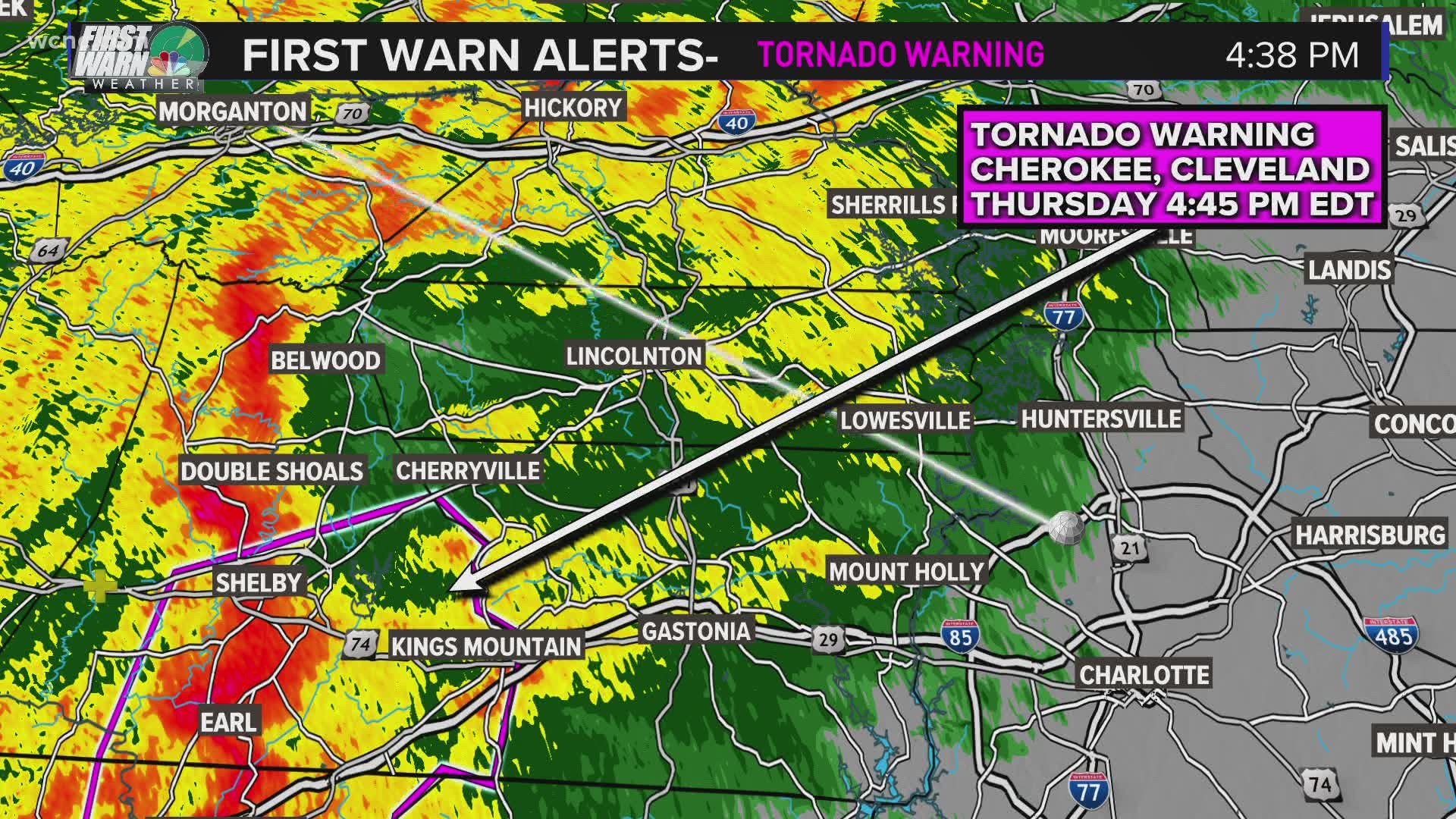
A previous tornado warning for Cleveland County, NC has been allowed to expire.
If you find yourself inside a tornado warning, you should:
- Head into a sturdy structure. Find a location inside the structure that is on the lowest possible level of the structure and the most interior location. You want to put as many walls between you and the outside as possible.
- Stay away from windows.
- If time allows, make sure you’re wearing the following as you head into shelter: Shoes, helmet, pants, and any other protective gear.
- A way to watch or listen to severe weather coverage to know the latest weather threat
Real-time radar:
The severe weather threat comes as a line of strong-to-severe thunderstorms continues pushing eastward into the Charlotte metro.
A line of severe thunderstorms is moving eastward across the Carolinas. Over the course of Thursday afternoon the line of storms, known as a QLCS, prompted the National Weather Service to issue several tornado warnings.
While the entire line of storms is not considered severe, it is advised everyone stays weather-aware and continues to monitor for quick-forming severe weather.
QLCS, which stands for a quasi-linear convective system, is the meteorological term for a squall line. On radar, the system would be recognized as a line of thunderstorms moving more-or-less at the same speed and same direction.
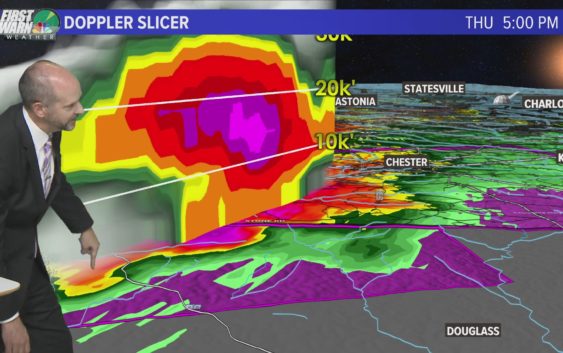
The following video, recorded at 4:40 p.m. during Thursday’s severe weather coverage, explains the severe weather threat from a QLCS line of thunderstorms.
The possible-tornadic rotations seen Thursday in the Carolinas are caused by rotation inside these strong-to-severe thunderstorms.
The following video, recorded at 5:15 p.m. during Thursday’s severe weather coverage, explains how rotation is detected on radar inside severe thunderstorms capable of producing tornadoes:
While some scattered strong-to-severe storms are possible in the Carolinas, the nation’s biggest and most extreme risk is again over Mississippi, Alabama, Georgia, and Tennessee — just a week after the Mid-South region also faced the same risk.
Chief Meteorologist Brad Panovich said Charlotte’s overall threat for severe weather is low, but some areas south and east of I-85 could get thunderstorms. Charlotte’s risk of severe weather remains low because the system will move through the area early Friday before the heating of the day produces thunderstorm fuel.
Panovich said the North Carolina mountains could be at risk for flash flooding and damaging winds as the first batch of storms moves in Thursday evening. Areas on the eastern-facing slopes are at the highest risk of localized flooding.
“The overall threat is low, but I actually think the biggest risk, believe it or not, for severe weather might be in the mountains around 8 or 9 o’clock as those storms that form earlier in the day make a run at us,” Panovich said.
The good news is the threat for severe weather for most of the Charlotte region is much lower than last week, when strong storms rocked the region with multiple tornado warnings. Damaging winds will be the primary threat in Charlotte, with some flash flooding possible in the mountains. The hail and tornado risk is minimal, but not non-existent.
“It’s one of those events where the threat is not huge but it’s also not zero,” Panovich said. “We’ve got to keep a close eye on that potential tonight because I do think some of these storms, one or two might become severe this evening into the overnight.”
By early Friday morning, between 2 a.m. and 5 a.m., the storms will begin to weaken as they move through the Charlotte area. The timing works out well for reducing our severe weather threat, plus Panovich says the majority of the energy in the system is above the Great Lakes and Midwest.
“I would definitely be a little more weather-aware than normal,” Panovich said. “But on a scale of 1 to 5, we’re probably closer to a 1 for tornadoes, as opposed to like a 3 last week.”
Panovich recommends everyone have two ways to receive severe weather alerts, including the WCNC Charlotte app, which will send alerts to users based on their location.