- Rock Hill storm damage costs are 'somewhere around $5 million.' That number doesn't include damage to personal property
- Rock Hill storm damage costs are 'somewhere around $5 million.' That number doesn't include damage to personal property
- ‘Somewhere around $5 million’ | Rock Hill officials see major storm damage costs
- The deadliest tornadoes to ever hit Austin
- Whiteville resident recalls events from Tuesday nights tornado
Tornado Warning for Cleveland County, North Carolina
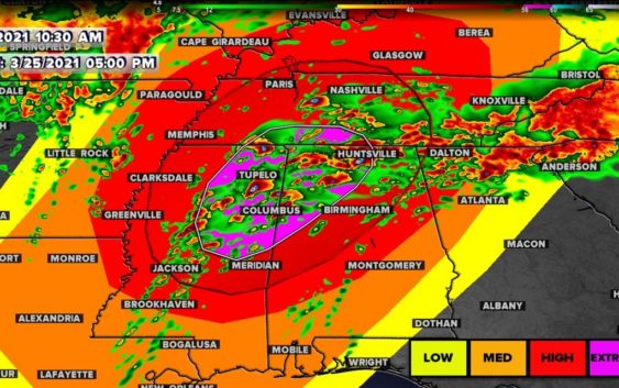
The first batch of storms will arrive in the Carolinas Thursday into Friday. Alabama, Mississippi, and Tennessee facing extreme risk again.
CHARLOTTE, N.C. — The WCNC Charlotte First Warn Storm Team is tracking a storm system that could bring rain and thunderstorms to the Carolinas Thursday into Friday.
While some scattered strong-to-severe storms are possible in the Carolinas, the nation’s biggest and most extreme risk is again over Mississippi, Alabama, Georgia, and Tennessee — just a week after the Mid-South region also faced the same risk.
Chief Meteorologist Brad Panovich said Charlotte’s overall threat for severe weather is low, but some areas south and east of I-85 could get thunderstorms. Charlotte’s risk of severe weather remains low because the system will move through the area early Friday before the heating of the day produces thunderstorm fuel.
Panovich said the North Carolina mountains could be at risk for flash flooding and damaging winds as the first batch of storms moves in Thursday evening. Areas on the eastern-facing slopes are at the highest risk of localized flooding.
“The overall threat is low, but I actually think the biggest risk, believe it or not, for severe weather might be in the mountains around 8 or 9 o’clock as those storms that form earlier in the day make a run at us,” Panovich said.
The good news is the threat for severe weather for most of the Charlotte region is much lower than last week, when strong storms rocked the region with multiple tornado warnings. Damaging winds will be the primary threat in Charlotte, with some flash flooding possible in the mountains. The hail and tornado risk is minimal, but not non-existent.
“It’s one of those events where the threat is not huge but it’s also not zero,” Panovich said. “We’ve got to keep a close eye on that potential tonight because I do think some of these storms, one or two might become severe this evening into the overnight.”
By early Friday morning, between 2 a.m. and 5 a.m., the storms will begin to weaken as they move through the Charlotte area. The timing works out well for reducing our severe weather threat, plus Panovich says the majority of the energy in the system is above the Great Lakes and Midwest.
“I would definitely be a little more weather-aware than normal,” Panovich said. “But on a scale of 1 to 5, we’re probably closer to a 1 for tornadoes, as opposed to like a 3 last week.”
Panovich recommends everyone have two ways to receive severe weather alerts, including the WCNC Charlotte app, which will send alerts to users based on their location.