- Rock Hill storm damage costs are 'somewhere around $5 million.' That number doesn't include damage to personal property
- Rock Hill storm damage costs are 'somewhere around $5 million.' That number doesn't include damage to personal property
- ‘Somewhere around $5 million’ | Rock Hill officials see major storm damage costs
- The deadliest tornadoes to ever hit Austin
- Whiteville resident recalls events from Tuesday nights tornado
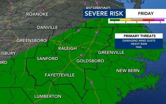
Level 1 risk for severe weather in place as central NC reaches the 80s
Raleigh, N.C. — Rain could become more widespread across the area Friday and storms are possible as temperatures reach the mid 80s.
A high around 85 degrees is expected in Raleigh, according to WRAL meteorologist Elizabeth Gardner. Scattered showers and a rumble of thunder will be possible leading up to lunchtime, then we’ll get a brief break before more rain and storms arrive.
Track rain with the DualDoppler5000
Much of the state is expected to be under a Level 1 risk for severe weather in the afternoon when thunderstorms and rain are likely, but those aren’t likely to last long.
The weather won’t be anything like what Alabama and Georgia witnessed Thursday, when a series of tornadoes killed at least five people.
Any storms will clear overnight, and Saturday will be dry but cloudy with a high in the upper 70s. There will be a chance for a stray shower Saturday afternoon, but the day won’t be a washout.
There is a greater chance for rain on Sunday. Temperatures will be in the 70s, but the humidity won’t be as high, so it’ll be a good day to be outdoors.

The best chance for showers and storms on Sunday will be late afternoon and in the evening.
By Monday, temperatures will be slightly cooler, in the mid 60s.
The warmth over the next four days will be comparable to our normal temperatures for the end of May.

It may appear that springtime warmth is here to stay, but WRAL meteorologists recommend waiting to plant delicate flowers and other seasonal additions to your garden. The average final spring freeze usually occurs between April 1-10 in the Triangle. The average date of the last hard freeze is anywhere from March 21-31.
With springtime comes an increase in pollen and allergies, and our chances of feeling that impact will increase as the week goes on.