- Whiteville resident recalls events from Tuesday nights tornado
- Tornado damage reported in southern NC after Tuesday's severe storms
- If your home floods, here are steps you can take to address mold
- WATCH: Video Shows Confirmed Tornado touches down in Columbus County
- Residents begin clean up after storms, apparent tornado roll through NC Tuesday
Another round of severe storms: Central NC under Level 2 risk of severe weather on Sunday
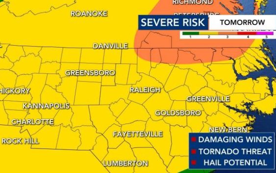
Raleigh, N.C. — Another round of storms is on the way to central North Carolina for Sunday after hail, tornado damaging winds and power outages were reported on Saturday from storms.
Temperatures will be in the 70s, but the humidity won’t be as high.
“What we saw [Saturday] may very well happen again [Sunday],” explained WRAL meteorologist Zach Maloch.
Maloch said the timing may be just a little bit different, but the threats could be greater.
“Damaging winds, tornado threat and hail potential are all on deck for Sunday,” he added.
All weather alerts can be found here.
The entire WRAL viewing area is under a Level 2 or Level 3 risk for severe weather on Sunday.
By 2 p.m. a line of strong to severe thunderstorms will begin to make its Orange and Durham counties. The line of storms will move into Raleigh soon after that, according to Maloch and could produce damaging wind gusts, as well as a possible tornado.
“We had a lot of hail Saturday, we could still have that threat Sunday,” said Maloch.
Track rain with the DualDoppler5000.
By 5 p.m. storms are expected to be in counties south of the Triangle. Lingering showers could continue throughout the evening.
Damage reported from Saturday’s storms
Severe storms moved across central NC on Saturday afternoon, spawning tornado warnings, pea-sized hail, power outages and lightning strikes.
The main threat was damaging wind gusts, which reached up to 60 mph. Pea-sized hail was seen falling in High Point, Durham, Chapel Hill and Raleigh. The heavy rain caused “white out conditions,” forcing drivers to be cautious on the roads.
On Saturday afternoon, around 1,000 customers were without power in the Triangle area.
One home in Raleigh was singed after a reported lightning strike. Fire fighters were on the scene.
WRAL cameras showed an ominous, dark shelf cloud moving across downtown Raleigh, as heavy storms moved through. Some WRAL viewers sent photos of eerie clouds, storm damage and hail in their areas.
People impacted by the passing storms shared photos of hail that fell in multiple counties around cental NC. A sizable amount of hail was shown on a highway near Greensboro.
Cooler temps on the way
By Monday, temperatures will be slightly cooler in the mid 60s.
The warmth over the next four days will be comparable to normal temperatures in the region for the end of May.
It may appear that springtime warmth is here to stay, but WRAL meteorologists recommend waiting to plant delicate flowers and other seasonal additions to gardens. The average final spring freeze usually occurs between April 1 and April 10 in the Triangle. The average date of the last hard freeze is anywhere from March 21 to March 31.
With springtime comes an increase in pollen and allergies, and the chances of feeling that impact across the region will increase as the week goes on.
