- North Carolina behind on hurricane preparedness, study shows
- North Carolina way behind on hurricane preparedness, study shows
- New hurricane preparedness report doesn't rank North Carolina well
- New hurricane preparedness report doesn't rank North Carolina well
- Southport hosts annual Hurricane Expo ahead of the 2024 season
Tornado Watch issued as storms develop around San Antonio area
Expect more dreary weather this week
Tornado watch issued for areas West of San Antonio.
National Weather Service
Severe weather threat continues for the San Antonio area.
National Weather Service
If you thought the sun was sticking around this time, think again.
Josie Norris, Staff / San Antonio Express-News
Heavy rain could produce 2-4 inches of rain, NWS says.
National Weather Service
San Antonio is likely to see severe storms this week.
National Weather Service
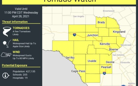
Update: The National Weather Service has issued a tornado watch for areas west of San Antonio, including Boerne and the Hill Country until 11 p.m. Wednesday.
According to the NWS, the San Antonio area still has a shot of strong to severe storms tonight with large hail. They note the severe threat will transition to a heavy rainfall threat later Wednesday night through Thursday morning.
Parts of the area could see anywhere from 2 to 4 inches of rain. Some areas could see up to 6 inches of precipitation.
Original story:
San Antonio is now under a slight risk for severe storms, according to the latest update from the National Weather Service.
The weather powerhouse announced Tuesday that the Alamo City faces a slight risk for excessive rainfall between Wednesday afternoon and Thursday morning, particularly Wednesday around 9 or 10 p.m.
If so, San Antonio could face one to two inches of rain depending on the severity of the storm. Along with rainfall, the storms could also bring large hail and heavy winds as high as 60 mph. Experts from the National Weather service said a tornado in the area is possible.
READ MORE: Man pushing cannon in Texas gives new meaning to ‘right to carry’
The update also indicated that isolated and scattered storms are possible Tuesday night across the Rio Grande, the southern portion of the Edwards Plateau, and portions of the Hill Country, although specific details were not provided.
Those areas are likely to get more dreary weather later in the week as well. The Rio Grande and Edwards Plateau could possibly see severe storms continue into late Wednesday afternoon, while the rains could affect the Hill Country well into Thursday morning.
Read more from Sarah