- Rock Hill storm damage costs are 'somewhere around $5 million.' That number doesn't include damage to personal property
- Rock Hill storm damage costs are 'somewhere around $5 million.' That number doesn't include damage to personal property
- ‘Somewhere around $5 million’ | Rock Hill officials see major storm damage costs
- The deadliest tornadoes to ever hit Austin
- Whiteville resident recalls events from Tuesday nights tornado
Storm updates: A confirmed tornado, hail, power outages and street flooding from storms in South Texas
Several possible tornados threatened San Antonio and areas west of Bexar County overnight Wednesday into Thursday morning.
SAN ANTONIO — Several Thunderstorm Warnings were in effect overnight into Thursday morning as a powerful storm cell moves across south Texas, nearing Bexar County. As the cell moved into San Antonio, the storm strength diminished greatly. A Severe Thunderstorm Warning and Tornado Watch were in effect for much of Bexar County but has since been canceled. Much of the region saw pea-sized to up to apple-sized hail and heavy rain. Some street flooding was also reported. Rain is expected to taper off Thursday and it will feel noticeably cooler late week with afternoon temperatures in the mid-70s to low-80s.
Latest Updates
5:45 a.m.-Due to large portions of the district not having electricity, as well as some district facilities, all Medina Valley ISD campuses will be closed today.
5:30 a.m.-More than 5,000 are without power as of 5:30 a.m. Thursday as the result of 172 active outages across Bexar County. See the below map from CPS Energy for the latest.
4:55 a.m.- The National Weather Service says there are still scattered showers and storms producing lightning and heavy rain but they do not pose a severe threat this morning.
3 a.m. -The National Weather Service said the storms had weakened below severe limits, but that minor flooding issues may still exist at low water crossings.
————
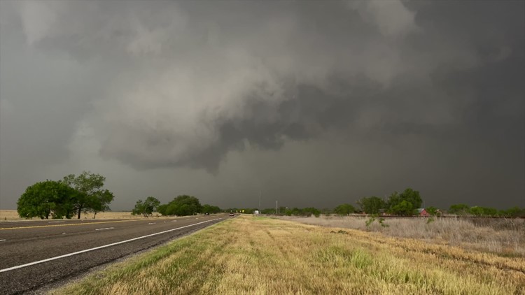
A confirmed tornado touched down 11 miles west of Hondo. Damage on the road and power flashes were observed, according to an official spotter report from the National Weather Service.
See video of that tornadic supercell in Hondo below:
In Medina County, a large tornado was spotted moving east over Highway 90 west of Hondo. Debris was spotted in the air The National Weather Service says those in Hondo need to take shelter.
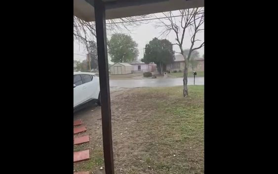
Afternoon storms brought hail raining down in south Texas communities, some of it large apple-sized.
This is a developing weather event. Refresh the page for the latest updates.
SEVERE WEATHER 101
When severe weather threatens the area, it is important to know what risks a storm can bring and what you should do to stay safe.
One of the most important things to know is where you are located on a map, so when a watch or warning is put into place, you can identify if you are at risk. When the National Weather Service puts out warnings, they are county-based and sometimes include cities as well. It is important to know where you live in the county and that you can identify it on a map.
It is also important to know the difference between a watch and a warning. A watch means that conditions are favorable for something to happen, but a warning means that something has developed and it is important to take action.
So, what would cause a thunderstorm to be qualified as a “severe” thunderstorm?
Hail that is one inch large is also considered to be about the size of a quarter.
Another ingredient that would lead to a storm becoming severe is if winds are 58 mph or greater.
Winds at this strength could cause damage to roofs and could even cause trees to be knocked down.
Finally, if a tornado is present inside a thunderstorm it would qualify the storm as becoming severe.
In this instance, a tornado warning would be issued.
A tornado watch can be issued for an area if strong storms are expected, and if the storms bring the risk for tornadoes, but not all storms include the threat for tornadoes. The ingredients in the atmosphere for a tornado to form are not always there when storms are present.
If the area you are in is ever under a tornado warning, it is important to know where you should go inside your home.
Head to the lowest, interior room of your home. The basement would be best, but if you don’t have one, head to the first floor of the home and get away from exterior walls, or walls that lead to the outside of the home.
It is also important to stay away from glass. The more walls you can put between you and the outside, the better.
While lightning can be frequent in storms and very dangerous, it does not lead to a storm being qualified as severe.
Remember, when thunder roars, go indoors.
Storms can also lead to flooding. Flooding may not cause a storm to be labeled as being severe, but it is the deadliest kind of weather.
South Texas is known to have major flood events every few years, so it is important to use caution and to always stay out of floodwaters. Remember, turn around, don’t drown.
Entering flood water is very dangerous as you can be swept off of your feet and you don’t know what could be in the water that could hurt you.
The best thing you can do to be ready for severe weather is know what you will do in the event it strikes where you live.
Make sure your family has a severe weather action plan.
Have a place everyone goes inside your home and keep supplies there, such as food, medication, batteries, and flashlights.
Weather Minds Classroom: Take a class in Severe Weather 101
Follow the KENS 5 Weather Team
Don’t forget you can download the KENS 5 app for the latest news and weather information each day while you are on the go.