- Mosquito activity on the rise due to rainfall, flooding across Texas
- Volunteers help Conroe community clean up in wake of flooding in Montgomery County
- Why leaders are urging NC residents to start hurricane prep now
- Storms could produce hail, damaging winds south of Charlotte
- Large hail and strong winds cause damage in San Marcos and the Hill Country
TIMELINE: When to expect heavy rainfall in the Houston area; isolated street flooding possible
The KHOU 11 Weather team is closely monitoring storms and heavy rain that will start to increase Friday morning.
HOUSTON — Storms and rain will soon make their way to the Houston area with some isolated high water spots possible.
The good news is, currently, we are not expecting widespread flooding, and the National Weather Service has not issued any watches or warning for our area.
WEATHER ALERTS: Get the KHOU 11 mobile app and sign up for weather notifications
WEATHER RADAR: Track storms, rain across Southeast Texas
The forecast is constantly changing, however, so we will continue to update this timeline as we learn more.
Timeline: When to expect the heaviest rain, storms in Houston
THURSDAY AM: Moisture started streaming in off the Gulf of Mexico from our breezy winds that kicked in on Wednesday. Muggy and in the 70s this morning but with only a very slight rain chance.
THURSDAY PM: The rain chance increases to 40% by the mid-afternoon hours, 3 to 4 p.m. Scattered thunderstorms are possible as well as we head from the afternoon into the evening. Scattered rain only continues tonight.
FRIDAY AM: The rain chance really picks up with heavy downpours likely before you wake up and through the morning rush hour commute. Expect slippery roadways and thunderstorms.
FRIDAY PM: Rain chances decrease a little as we head into the late afternoon and evening hours on Friday, but scattered showers are still possible overnight into Saturday.
SATURDAY AND SUNDAY: We’re looking at continuing widespread showers with a 60% rain chance. While it may not be as heavy as Friday morning’s rainfall, now is when we will want to keep an eye out for ponding on the roadways and isolated high water spots as the grounds will be very saturated by this point. It’s too soon to know for sure or know which areas will be the most impacted by flooding, if any.
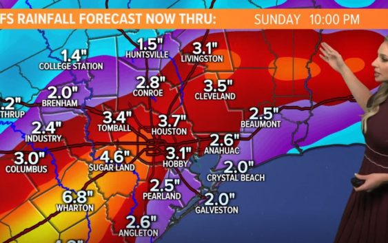
You can see in this image below most areas can expect to get about 3 to 4 inches of rain now through Sunday night with the heaviest rainfall reported in Houston proper and areas to the southwest through Sugar Land and Wharton.
NEXT WEEK: Light scattered showers continue Monday and Tuesday — we won’t have a really nice, sunny day again until Wednesday.