- Rock Hill storm damage costs are 'somewhere around $5 million.' That number doesn't include damage to personal property
- Rock Hill storm damage costs are 'somewhere around $5 million.' That number doesn't include damage to personal property
- ‘Somewhere around $5 million’ | Rock Hill officials see major storm damage costs
- The deadliest tornadoes to ever hit Austin
- Whiteville resident recalls events from Tuesday nights tornado
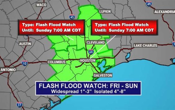
TIMELINE: Flash Flood Watch going into effect for southeast Texas Friday morning
The KHOU 11 Weather team is closely monitoring storms and heavy rain that will start to increase Friday morning.
HOUSTON — The National Weather Service has issued a Flash Flood Watch for southeast Texas, beginning at 4 a.m. Friday and lasting through 7 a.m. Sunday morning.
The areas under the Flash Flood Watch includes the following counties: Austin, Brazoria, Chambers, Colorado, Fort Bend, Galveston, Grimes, Harris, Jackson, Liberty, Matagorda, Montgomery, Polk, San Jacinto, Trinity, Walker, Waller, Washington and Wharton
According to the National Weather service, showers and storms will move in from the north early Friday morning. One to three inches of rain is expected, but there could be some training of heavier storms that can cause areas of between four and eight inches.
Watch out for areas that are prone to flooding.
WEATHER ALERTS: Get the KHOU 11 mobile app and sign up for weather notifications
WEATHER RADAR: Track storms, rain across Southeast Texas
The forecast is constantly changing, however, so we will continue to update this timeline as we learn more.
Timeline: When to expect the heaviest rain, storms in Houston
THURSDAY PM: The rain chance increases overnight, especially in our northwest counties.
FRIDAY AM: The rain chance really picks up with heavy downpours likely before you wake up and through the morning rush hour commute. Expect slippery roadways and thunderstorms.
FRIDAY PM: Rain chances decrease a little as we head into the late afternoon and evening hours on Friday, but scattered showers are still possible overnight into Saturday.
SATURDAY AND SUNDAY: We’re looking at continuing widespread showers with a 60% rain chance. While it may not be as heavy as Friday morning’s rainfall, now is when we will want to keep an eye out for ponding on the roadways and isolated high water spots as the grounds will be very saturated by this point. It’s too soon to know for sure or know which areas will be the most impacted by flooding, if any.
You can see in this image below most areas can expect to get about 3 to 4 inches of rain now through Sunday night with the heaviest rainfall reported in Houston proper and areas to the southwest through Sugar Land and Wharton.
NEXT WEEK: Light scattered showers continue Monday and Tuesday — we won’t have a really nice, sunny day again until Wednesday.