- EF-1 tornadoes ripped through Cypress, Waller County areas with winds at more than 100 mph, NWS reports
- Houston-area storm damage updates: Clean up continues after NWS says two EF-1 tornadoes and powerful derecho ripped through SE Texas
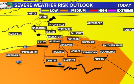
- Low risk of damaging winds, hail from Saturday storms
- EF 1 tornadoes ripped through Cypress, Waller County areas at more than 100 mph, NWS reports
- Caddo Mounds State Historic Site to celebrate new visitor center, traditional grass house after 2019 tornado
Tornado Warning in Gaston, York counties
The Charlotte area will be at risk for heavy rain, lightning, hail and isolated tornadoes. Brad Panovich says the threat will last through Wednesday.
CHARLOTTE, N.C. — A cluster of thunderstorms will bring the threat of severe weather to the Charlotte, North Carolina, region and the Carolinas multiple days this week.
WCNC Charlotte Chief Meteorologist Brad Panovich said the biggest threat from these storms will be damaging, straight-line winds but he could not rule out the possibility of isolated tornadoes, heavy rain, lightning and hail.
“The next three days are going to be active, to say the least,” Panovich said.
The entire Charlotte area is at risk for severe weather, although the greatest risk appears to be south and west of the Queen City. Everyone across the foothills and Piedmont of North Carolina should be prepared for severe weather.
As of 10:55 a.m., nearly 3,000 Duke Energy customers in Charlotte are without power. The majority of those customers are in the NoDa area, although more than 750 outages were reported near Charlotte Douglas International Airport.
“Our primary concern is straight-line winds,” Panovich said. “Any time you have severe weather there’s at least a small risk for tornadoes, but it’s only about 1-2%. Don’t rule it out, but the severe threat is primarily driven by damaging winds.”
Panovich said a cluster of storms will move through the Charlotte area around lunchtime Monday. These scattered storms will bring heavy rain and lightning to the area. The second cluster of storms is expected to move through the area Monday afternoon with a greater chance of severe weather due to the heating of the day.
“A cluster of storms will move through in the middle of the day, around 11 or 12. Then it gets pretty crazy,” Panovich said. “Another bunch moves through in the afternoon. It may be stronger, so we’ll keep an eye on it around 3 or 4 o’clock.”
Panovich said areas south and west of Charlotte, as well as along I-85 will be at the greatest risk of severe weather Monday. These areas include Chester, Lancaster, and Rock Hill in South Carolina, as well as Gastonia, Concord and Albemarle in North Carolina.
Tuesday will see another threat of strong storms in the afternoon. Panovich said the current setup looks like what’s known as a “bow echo,” which can have supercells embedded along a line of storms.
RELATED: What is a bow echo?
“To me, this is more of a worrisome setup,” Panovich said. “This is likely going to be shifted east at some point. At 4 o’clock, it’s expected to be over Charlotte and I-77 and will continue to push east Wednesday.”
Contact Brad Panovich at bpanovich@wcnc.com or follow him on Facebook, Twitter and Instagram.