- WATCH: Video Shows Confirmed Tornado touches down in Columbus County
- Residents begin clean up after storms, apparent tornado roll through NC Tuesday
- NC State researchers find increased fecal contamination in coastal waters due to sunny day flooding
- Flooding lingers in Liberty County neighborhoods near Trinity River with more rainfall expected
- North Carolina behind on hurricane preparedness, study shows
Flash Flood Watch Expanded
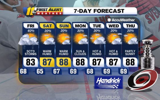
RALEIGH, N.C. (WTVD) — Heavy rain remains possible through the evening, and the Flash Flood Watch has been expanded to include most of central North Carolina. Parts of the area picked up 1-2″ or rain yesterday, and an additional 1-4″ of rain could fall through tonight possibly leading to flash flooding. We’re also under a marginal risk, level 1 out of 5, for severe weather. Damaging winds are the main threat, and an isolated tornado also can’t be ruled out. We’ll get a lull in the rainfall around midnight.
Flash Flood Watch Expanded. Most of the area is now under a flash flood watch through early Friday morning. 1-4 inches of rain could fall tonight. pic.twitter.com/pVOBRMbvcy
— Brittany Bell (@BrittanyABC11) June 3, 2021
A cold front weakens as it moves across the state Friday, but that front will help to spark another round of scattered rain. Most of the rain Friday will fall during the morning, and showers taper off during the afternoon. Highs will reach the low 80s.
High pressure settles nearby this weekend lowering rain chances. We’ll see more sunshine with highs in the upper 80s and the low 90s in the Sandhills.
A typical summer like pattern develops next week. Highs will reach the upper 80s with a chance for a few pop up storms during the afternoon.
Have a great evening!
-Brittany Bell
Copyright © 2021 WTVD-TV. All Rights Reserved.