- Flooding lingers in Liberty County neighborhoods near Trinity River with more rainfall expected
- North Carolina behind on hurricane preparedness, study shows
- North Carolina way behind on hurricane preparedness, study shows
- New hurricane preparedness report doesn't rank North Carolina well
- New hurricane preparedness report doesn't rank North Carolina well
Parts of Triangle under Level 1 risk for severe weather on Monday
Raleigh, N.C. — Sunday’s weather was warm, breezy and less humid than the past week has been. Temperatures reached 87 degrees, but it still felt pleasant outside.
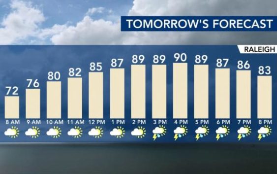
But we hope you enjoyed the sunshine, because Monday our chance of rain returns. Monday is expected to be warm, with scattered showers across the Triangle.
Some of our communities are under a Level 1 risk for severe weather on Monday. That means that heavy rain and damaging winds will be possible in areas north and northeast of Raleigh.
“Tomorrow morning we will start dry,” WRAL meteorologist Zach Maloch said. “But come the afternoon, that’s when scattered showers and storms pop right back up.”
Maloch says highs Monday will get back into the upper 80s, even 90, and the storms should start in our area around the middle of the afternoon.
Subscribe to the daily WRAL Weather forecast newsletter
On Tuesday, a cold front clears early in the morning and while a few showers are possible, Tuesday will be drier.

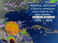
Meteorologists also are keeping an eye on a system in the Pacific. If it crosses the Bay of Campeche and emerges in the Gulf of Mexico on Sunday, it has a 40 percent chance to develop into a tropical system in the following five days.
This system is not likely to affect our weather in North Carolina.