- EF-1 tornadoes ripped through Cypress, Waller County areas with winds at more than 100 mph, NWS reports
- Houston-area storm damage updates: Clean up continues after NWS says two EF-1 tornadoes and powerful derecho ripped through SE Texas
- Low risk of damaging winds, hail from Saturday storms
- EF 1 tornadoes ripped through Cypress, Waller County areas at more than 100 mph, NWS reports
- Caddo Mounds State Historic Site to celebrate new visitor center, traditional grass house after 2019 tornado
Heavy rain, tornado risk near Triangle as Tropical Depression Claudette moves into North Carolina
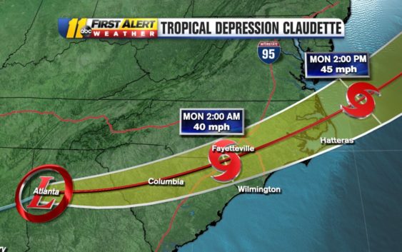
RALEIGH, N.C. (WTVD) — After bringing life-threatening flash flooding to the Gulf Coast, Tropical Storm Claudette was downgraded to a tropical depression and is moving quickly toward North Carolina.
As of Sunday morning, Claudette is 85 miles west-southwest of Atlanta and moving at about 13 miles per hour. The storm has maximum sustained winds of 30 miles per hour.
The system is expected to continue on its path through Georgia and into North Carolina on Sunday, exiting into the Atlantic Ocean sometime Monday morning.
Claudette will bring heavy rain to parts of North Carolina. The bulk of the storms are likely during the day and evening Sunday.
T.D. Claudette is near Atlanta, heading towards the Sandhills tonight. Fast moving so rain fall generally 1-2″ with a chance for an isolated strong to severe storm. Dry, hot and humid tomorrow as the storm will likely be moving offshore early in the morning. pic.twitter.com/QmOsoqqEs5
— Steve Stewart (@StewartABC11) June 20, 2021
The greatest impacts will be felt over southern portions of the region, closer to the track of the storm’s center. The main impact will be heavy downpours and possible flooding for Charlotte and areas along Interstate 74 with steady winds of 15 to 25 mph.
It will be much cooler Sunday afternoon after a hot and sticky Saturday.
Periods of tropical showers and storms today. Heavy at times with the threat of an isolated tornado later today, mainly south and east of the Triangle as T.D. Claudette moves across the southern part of our state pic.twitter.com/bloQUw2oQD
— Steve Stewart (@StewartABC11) June 20, 2021
As Claudette moves over eastern North Carolina on Monday, there will still be some strong winds, rough surf and rip currents at the coast.
Here’s an idea of what the radar will look like for #FathersDay.
Generally, more rain for the Sandhills and southern half of the Coastal Plain (around 1-2″). Less rain for the Triangle and points to the north (about half an inch to 1″). pic.twitter.com/K0kORudsrc
— Robert Johnson (@RobJohnsonABC11) June 19, 2021
Interestingly enough, this tropical depression could actually strengthen back into a tropical storm while over North Carolina.
This is because Claudette will be able to draw energy from the warm coastal waters as it moves closer to the ocean. Plus, it currently has sustained winds of 30 miles per hour–it just needs winds at 39 miles per hour to go back to being a tropical storm.
Practically speaking, there’s very minimal difference between a tropical depression and a tropical storm for people on the ground.
A Tropical Storm Watch is in effect from Cape Fear to Duck, including the Pamlico and Albemarle Sounds.
Rain could be heavy at times and there could be a threat for an isolated tornado pop up. Right now, the severe risk is highest for those south and east of the Triangle.
By Monday afternoon, the state will be drying out and hot.
Copyright © 2021 WTVD-TV. All Rights Reserved.