- Southport hosts annual Hurricane Expo ahead of the 2024 season
- How to protect your car before a hailstorm
- ‘We lost everything’: East Texas residents confront their future after flooding
- Here's how to get your flooding debris picked up by the City of Houston
- Mosquito activity on the rise due to rainfall, flooding across Texas
Tropical Depression Claudette expected to gain strength, more tornado warnings possible
Raleigh, N.C. — A Tropical Storm Warning has been issued for the North Carolina coast and most of the state’s coastline — from Cape Lookout to the Virginia border — could experience storm surge. The National Hurricane Center says tropical storm conditions are possible Sunday night and Monday morning at North Carolina beaches.
The center of Tropical Depression Claudette made its way into South Carolina on Saturday afternoon. Ahead of this are showers and storms which could spawn an isolated tornado.
“We expect it to weaken just a little bit more throughout the day, and then it’s going to re-strengthen,” said WRAL meteorologist Peta Sheerwood.
The system is bringing the threat of flooding and heavy rains to North Carolina. Heavy rain and storms were making their way through the Triangle on Sunday afternoon as 20 North Carolina counties are under alerts related to flooding, including Wayne and Sampson counties.
A tornado warning was issued for Union County until 3:30 p.m. No tornados have been reported or confirmed in the state, as of Sunday afternoon.
Tornados are most likely in areas southeast of Wake County, from Robeson County all the way up to Bertie Coutny.
The National Weather Service said residents in Johnston, Harnett, Sampson and Wayne counties could see more severe storms due to current conditions. The main hazard to be on the look out for is damaging winds, officials said.
Nearly 1,000 people were without power in Siler City on Sunday evening.

Overnight, the center of circulation for Claudette should move through North Carolina. It has potential to bring winds of around 45 mph, especially if it re-strengthens into a Tropical Storm.
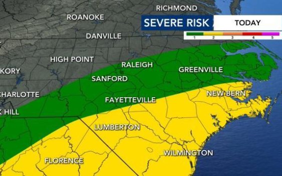
Expect to see on-and-off rain and some flooding on Sunday, Maloch said. Winds are not as big of a threat for North Carolina Sunday and Monday. Parts of the state, including Wake County, are under a Level 1 risk for severe weather Sunday. The threat means there will be a chance for damaging winds, heavy rainfall and tornados.

An area of low pressure will stay south of North Carolina, which Maloch says is good news. This means our chances of tornados forming are low.
More showers are possible on Monday night from the storm.

“By the time it gets to us, it would be a remnant low pressure system,” said WRAL meteorologist Kat Campbell.
Claudette has already torn through southern states, including Louisiana and Alabama, causing major destruction and leaving flood waters in its wake.
Threat of more storms on Tuesday
There should be a break in the rain Monday night, but a cold front Tuesday will deliver another round of showers and thunderstorms.
Rainfall totals could reach 1.5 inches by Tuesday in the Triangle. The heaviest amounts of rain would appear in our southwestern counties with severe weather possible in the southeast half of the viewing area.

“Rain will be more impactful than wind, but we could see some gusts up to 35 miles per hour,” said Campbell, adding that the tornado threat will depend on the exact track of the system.
The National Weather Service said the system is expected to produce heavy rain and flash flooding along the Gulf Coast states. Tropical storm conditions are expected to start Friday from Intracoastal City, La. to western Florida. Those same conditions are possible along parts of the North Carolina coast on Sunday night and Monday.
There is a high risk for flash flooding for some Gulf Coast states on Saturday.
Officials say the storm demolished or badly damaged at least 50 homes in a small town just north of the Florida border and a suspected tornado “pretty much leveled” a mobile home park.

Claudette is the first named storm to make landfall in the United States during the 2021 Atlantic Hurricane season