- EF-1 tornadoes ripped through Cypress, Waller County areas with winds at more than 100 mph, NWS reports
- Houston-area storm damage updates: Clean up continues after NWS says two EF-1 tornadoes and powerful derecho ripped through SE Texas
- Low risk of damaging winds, hail from Saturday storms
- EF 1 tornadoes ripped through Cypress, Waller County areas at more than 100 mph, NWS reports
- Caddo Mounds State Historic Site to celebrate new visitor center, traditional grass house after 2019 tornado
Central NC dries up as Tropical Storm Claudette begins to shift away from coast
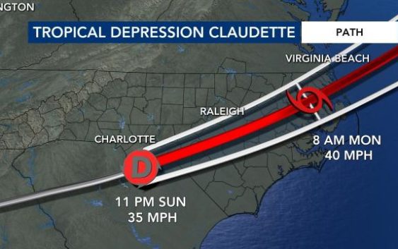
Raleigh, N.C. — The Triangle is dry as Tropical Storm Claudette begins to pull away from the coast.
Some coastal communities are still under a Tropical Storm Warning – with some rain and storms, with windy conditions and choppy waves.
“We’ve got some pretty rough surf out there,” said WRAL meteorologist Aimee Wilmoth. “Anywhere from 5 to 9 feet.”
However, we’ll have improving conditions all across North Carolina as we move into the afternoon hours.
“We’ll have some sunshine. By 2 p.m., Claudette is completely off our coast,” said Wilmoth.
Storms had no impact on Monday morning’s commute in central NC, except a few lingering wet spots from Sunday’s rainfall.
“For the morning commute, expect a cloudy start, damp roads from all the rain we’ve seen, but not a lot of rain, so minimal impact,” said WRAL meteorologist Zach Maloch.
By Monday afternoon, we’ll see partly cloudy skies with hot and humid temperatures. Monday’s high is 92 degrees.
On Tuesday, a passing cold front brings another round of stormy weather and rain.
Conditions on the North Carolina coast
WRAL’s cameras show waves raging and rain falling at Carolina Beach.
Video from Oak Island shows rain bands dropping enough precipitation to leave water standing on the roads.
WRAL’s Kasey Cunningham stayed overnight at Wrightsville Beach, where heavy rain and potential for flash flooding were the main concerns. Winds are also pretty heavy on the coast.
Brunswick County schools are opening late because of the threat of severe weather.
Storms and floods as Claudette passed over the state on Sunday
A Tropical Storm Warning was issued for the North Carolina coast and most of the state’s coastline — from Cape Lookout to the Virginia border — experienced a storm surge. The National Hurricane Center says tropical storm conditions are possible overnight Sunday night and Monday morning at North Carolina beaches.
The system brought flooding and heavy rains to North Carolina. The rain and storms made their way through the Triangle on Sunday afternoon as 20 North Carolina counties ended up under alerts related to flooding, including Wayne and Sampson counties.
A tornado warning was issued for Union County until 3:30 p.m. No tornadoes were ever reported or confirmed in the state, as of Sunday night.
Nearly 1,000 people were without power in Siler City on Sunday evening.
Damage down south
Claudette has already torn through southern states, including Louisiana and Alabama, causing major destruction and leaving flood waters in its wake.

Officials say the storm demolished or badly damaged at least 50 homes in a small town just north of the Florida border and a suspected tornado “pretty much leveled” a mobile home park.
Claudette is the first named storm to make landfall in the United States during the 2021 Atlantic Hurricane season