- WATCH: Video Shows Confirmed Tornado touches down in Columbus County
- Residents begin clean up after storms, apparent tornado roll through NC Tuesday
- Flooding lingers in Liberty County neighborhoods near Trinity River with more rainfall expected
- North Carolina behind on hurricane preparedness, study shows
- North Carolina way behind on hurricane preparedness, study shows
Stormy, humid weather returns: Triangle under Level 1 severe weather threat Tuesday
Raleigh, N.C. — Tropical Storm Claudette moved out to the Atlantic Ocean, and sunshine finally returned to North Carolina.
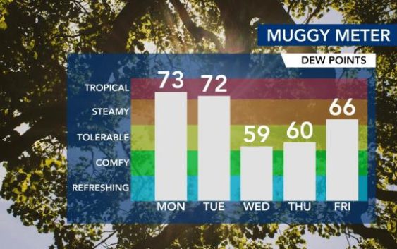
Monday will be muggy and hot, with highs in the low 90s and a head index reaching 100 degrees.
“It’s like when Claudette left, the humidity stayed — or at least the tropical air did,” said WRAL meteorologist Mike Maze.
Temps are not planning to cool off on Monday night, Maze said.
A cold front moving through Tuesday brings more rain and storms.
The Triangle is under a level 1 risk for severe storms on Tuesday, with the threat of damaging winds, heavy rain and potential for flooding. Expect to see storms on Tuesday in the late afternoon and early evening.
“Storms are possible by lunchtime in our northwest counties,” said WRAL meteorologist Aimee Wilmoth.

Behind the cold front and stormy weather, temperatures on Wednesday will begin to cool down, and the humidity should dip as well.
Wednesday’s dew points will drop into the 50s, with a forecast high temperature of 79 degrees.
By Thursday and Friday, dew points will pick back up as temperatures rebound into the mid-80s heading into the weekend.
