- EF-1 tornadoes ripped through Cypress, Waller County areas with winds at more than 100 mph, NWS reports
- Houston-area storm damage updates: Clean up continues after NWS says two EF-1 tornadoes and powerful derecho ripped through SE Texas
- Low risk of damaging winds, hail from Saturday storms
- EF 1 tornadoes ripped through Cypress, Waller County areas at more than 100 mph, NWS reports
- Caddo Mounds State Historic Site to celebrate new visitor center, traditional grass house after 2019 tornado
'Landfall is imminent': Tropical Storm Danny forms off SC coast
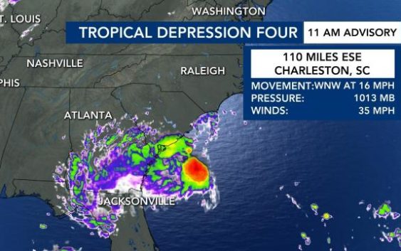
A Tropical Depression formed off the coast of South Carolina on Monday with maximum sustained winds of 35 mph. As of 3 p.m. Monday, the storm turned into Tropical Storm Danny.
“Landfall is imminent,” said WRAL meteorologist Kat Campbell, saying the storm could hit land as early as Monday evening.
This tropical depression will quickly move west northwest along the gulf stream, where water temperatures are around 82 degrees.
“With that warm sea surface temperature, we are likely to see some development,” said WRAL meteorologist Peta Sheerwood.
Landfall is forecast Monday evening along the South Carolina coast, near or south of Charleston.
The cluster of showers and storms is likely to impact Georgia, South Carolina and parts of Mississippi into the evening.
Tropical storm warnings could be posted for the coast of Georgia and South Carolina, but impacts across NC should be low.
“There is no rain for us from this system,” WRAL meteorologist Mike Maze said.
The system could bring rain for north Georgia and the North Carolina mountains on Tuesday.

Visitors to NC beaches should keep an eye on surf conditions, as the rip current risk is high along much of the NC coast through Tuesday.