- EF-1 tornadoes ripped through Cypress, Waller County areas with winds at more than 100 mph, NWS reports
- Houston-area storm damage updates: Clean up continues after NWS says two EF-1 tornadoes and powerful derecho ripped through SE Texas
- Low risk of damaging winds, hail from Saturday storms
- EF 1 tornadoes ripped through Cypress, Waller County areas at more than 100 mph, NWS reports
- Caddo Mounds State Historic Site to celebrate new visitor center, traditional grass house after 2019 tornado
Tropical Storm Danny forms off South Carolina coast, expected to make landfall Monday evening
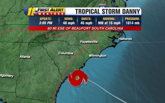
Tropical Storm Danny has formed off the coast of South Carolina.
The tropical depression could became a tropical storm Monday afternoon and is expected to make landfall in South Carolina near the Georgia border between 7 and 8 p.m.
That is expected to happen between 7 and 8 p.m.
Tropical Storm #Danny has formed off the coast of South Carolina. We are seeing some showers, especially in our southern areas, from the outer rain bands rain bands. it should make landfall this evening. #scwx #ncwx pic.twitter.com/kI4YQRrkxY
— 𝘿𝙤𝙣⚡𝙎𝙘𝙝𝙬𝙚𝙣𝙣𝙚𝙠𝙚𝙧 (@BigweatherABC11) June 28, 2021
The storm could produce between 1 and 3 inches of rain with locally higher amounts along the coasts of Georgia and southern South Carolina.
Tropical storm warnings were issued Monday for parts of the South Carolina coast, from Edisto Beach to the South Santee River. The National Hurricane Center said Monday that the tropical storm is about 60 miles east-southeast of Beaufort, South Carolina.
In North Carolina, there is a high risk for rip currents along the coast.
Full Special: First Alert to Hurricane Season
Copyright © 2021 WTVD-TV. All Rights Reserved.